Red rock walls rise from every direction as you round a bend, the Colorado River glinting a thousand feet below, and suddenly you understand why people spend their entire lives chasing this landscape. The Southwest isn’t a single destination—it’s a four-state corridor of geological extremes where you can stand at the edge of a mile-deep canyon at sunrise, hike through slot canyons so narrow you touch both walls, and watch Monument Valley’s iconic buttes glow orange at sunset, all within a single week.
What makes a Southwest road trip different from anywhere else: the sheer density of world-class stops compressed into drivable distances. You’re not choosing between one park or another—you’re hitting four to six major parks in 7–10 days, each one visually distinct enough that you won’t experience landscape fatigue.
The Grand Canyon’s scale, Zion’s intimate canyons, Bryce’s alien hoodoos, and Monument Valley’s iconic buttes feel like completely different planets, not variations on a theme.
This guide cuts through the decision paralysis and tells you exactly which stops justify your time, which ones to skip, and how to move between them without wasting daylight hours on logistics.
Budget ranges: free camping to $15/night (BLM sites), $25–$36/night (park campgrounds), $70–$120/night (gateway town motels), or $150–$300+/night (resort-style lodging in Sedona and Las Vegas).
The Four Must-Stop States at a Glance
Arizona: Grand Canyon South Rim (the anchor), Horseshoe Bend, Antelope Canyon, Monument Valley. Drive time between stops: 1.5–3 hours.
Utah: Zion National Park, Bryce Canyon, Coral Pink Sand Dunes, Sand Hollow State Park. Drive time between stops: 30 minutes to 1.5 hours.
Nevada: Las Vegas (overnight base), Red Rock Canyon, Valley of Fire, Hoover Dam. Drive time between stops: 30–60 minutes.
California: Death Valley, Joshua Tree, Eastern Sierra geothermal pools, Alabama Hills. Drive time between stops: 1–3 hours.
Timing matters more than anything else: October through April is the only window where heat won’t dominate your experience. Summer (May–September) exceeds 100°F+ and makes driving dangerous—avoid entirely.
Budget hack: The $80 Annual National Parks Pass pays for itself in two park visits. Buy it before you leave home.
When is the Best Time of Year to Plan a Southwest Road Trip?
October through April is the only window that makes the Southwest truly drivable—summer heat turns the desert into a furnace that will destroy your comfort, your vehicle’s A/C, and your itinerary. The Southwest is a four-state road trip (Arizona, Utah, Nevada, California) spanning some of the most remote terrain in the country, which means you’re spending 5+ hours daily in direct sun with limited shade stops. Plan wrong on timing, and you’ll spend your trip managing heat instead of exploring.
Fall (October–November): The Sweet Spot
October through mid-November is the ideal window for a Southwest road trip. Daytime temperatures range from the mid-70s to low 80s Fahrenheit in most parks and towns, dropping to comfortable 50s–60s at night—perfect for both driving and camping.
The summer crowds have cleared out, meaning shorter lines at popular stops like Zion and the Grand Canyon, easier parking, and more availability at campgrounds and hotels. Fall also brings clearer skies and sharper visibility for photography at red-rock formations and canyon overlooks.
If you’re driving a rental car or camper van, October-November is when your A/C won’t be working overtime, reducing mechanical strain and the risk of breakdowns in remote areas.
Winter (December–February): Cold but Passable
Winter is drivable but requires preparation and flexibility. Temperatures drop to 40s–50s during the day in lower elevations (Las Vegas, Arizona parks) but can dip below freezing at higher elevations like Bryce Canyon and Zion’s rim areas.
Snow is possible in Utah parks, especially January–February, which can close roads or require chains—confirm current road conditions with the National Park Service before booking. Winter offers the fewest crowds and lowest lodging prices of the year, making it appealing for budget-conscious travelers.
However, shorter daylight hours (sunset around 5 p.m.) compress your exploration time, and some scenic drives and trailheads may have limited access. Winter works best if you’re flexible on dates and can pivot if weather closes a park entrance.
Spring (March–April): Unpredictable but Rewarding
March through April brings warming temperatures (60s–70s) and wildflower blooms in desert areas, but weather is highly variable—expect sudden temperature swings, afternoon thunderstorms, and occasional late-season snow at higher elevations. Spring is less crowded than summer but busier than fall, so book lodging and campgrounds early.
Road conditions are generally clear by April, making it a solid backup option if fall dates don’t work. The main drawback is that you’ll share the road with spring-break travelers heading to Las Vegas and California, so expect heavier traffic on I-15 and popular park entrances.
Summer (May–September): Avoid
Summer is the worst time to drive the Southwest. Temperatures regularly exceed 100°F in Arizona and Nevada, climbing to 120°F+ in Death Valley and other low-elevation areas.
Your vehicle’s A/C will run constantly, increasing fuel consumption and mechanical failure risk—especially critical if you’re in a rental or older vehicle far from service centers. Daytime driving becomes dangerous; many travelers are forced to start hikes at dawn or skip them entirely because midday heat is unsafe.
Campgrounds and hotels are fully booked months in advance, prices spike 30–50% above shoulder-season rates, and parking at major parks fills by 9 a.m. Summer crowds also mean long wait times at entrance gates and popular viewpoints. The only exception: if you’re driving at night and sleeping during the day, summer is technically possible—but this inverts your entire itinerary and defeats the purpose of a scenic road trip.
Seasonal Comparison at a Glance
| Season | Best For | Temperature Range | Crowds | Key Consideration |
|---|---|---|---|---|
| Fall (Oct–Nov) | Most travelers | 70s–80s°F | Low | Ideal conditions; book early |
| Winter (Dec–Feb) | Budget travelers; flexible schedules | 40s–50s°F (freezing at elevation) | Very low | Check road closures; shorter daylight |
| Spring (Mar–Apr) | Wildflower seekers; flexible dates | 60s–70s°F (variable) | Moderate | Weather unpredictable; book early |
| Summer (May–Sep) | No one | 100°F+ (120°F+ in low areas) | Extremely high | Dangerous heat; avoid entirely |
Practical Booking Timeline
For a fall trip, book lodging and campgrounds 2–3 months in advance (July–August for October travel). Winter trips can be booked 4–6 weeks ahead unless you’re targeting specific holiday dates.
Spring requires the same lead time as fall due to unpredictable weather driving last-minute cancellations. Rental cars should be reserved early in fall and spring; winter and summer have more availability but higher prices in summer.
Check the National Park Service website for each park’s operating hours and entrance fees closer to your travel dates, as seasonal adjustments happen annually.
Vehicle Preparation by Season
If you’re driving your own car, ensure your A/C is serviced before any trip, especially fall and spring when you’ll be in the car 5+ hours daily. For winter travel, confirm your vehicle has good tread tires and consider carrying chains if visiting Utah parks.
Rental vehicles should be inspected for A/C function and tire condition before leaving the rental lot—mechanical failures in remote desert areas can strand you hours from the nearest service center. Camper vans and RVs are popular for Southwest road trips; if renting, book at least 2–3 months ahead for fall, as availability drops quickly.
How to Choose Your Road Trip Vehicle and Navigation Gear?
A broken gear shift in a Las Vegas parking lot will teach you fast: your vehicle choice makes or breaks a Southwest road trip before you even hit the first trailhead. The desert demands reliability, and that decision—rent or drive your own—determines your budget, stress level, and whether you’re stuck calling roadside assistance in 115-degree heat.
Rent vs. Drive Your Own Car
Skip your personal car if it’s older, has high mileage, or needs work done before the trip—the risk of breakdown in remote desert areas far outweighs the rental cost. A rental protects you with roadside support, warranty coverage, and the peace of mind that the vehicle was built for this exact trip.
Rent if you’re flying in or live far enough away that driving your own car to the Southwest costs more in gas and wear than a rental would.
Drive your own car only if it’s reliable, has low-to-moderate mileage, and you’ve had it serviced recently. You’ll save money on rental fees and have the flexibility to leave on your own schedule without worrying about return deadlines or mileage penalties.
This works best for travelers within a few hours of Arizona, Utah, Nevada, or California who own a vehicle they trust completely.
The non-negotiable detail: Verify your air conditioning works flawlessly before departure. You’ll be driving hours in direct sun with temperatures regularly exceeding 100 degrees—a broken A/C turns a scenic drive into a dangerous situation.
Vehicle Type: Standard Car vs. Camper Van vs. SUV
A standard rental car is the cheapest option and handles highway driving smoothly, but it limits your flexibility for free camping and remote overlanding spots. You’ll need to book hotels or paid campgrounds every night, which adds up fast across a multi-state trip.
A camper van or RV gives you the freedom to camp for free or cheap using sites like FreeCampsites.net or TheDyrt.com, and you can sleep anywhere legally parked—a major budget advantage on a long Southwest loop. The trade-off: higher rental costs upfront, slower driving speeds, trickier navigation through narrow canyon roads, and the risk of mechanical issues (like a failed gear shift) in places where repair shops are 50+ miles away.
Rent a camper van only if you’re comfortable with basic vehicle troubleshooting and have time built into your itinerary for unexpected repairs.
An SUV or truck splits the difference—better ground clearance for rough roads than a sedan, more cargo space for camping gear, and easier to handle than a full RV. Rental costs fall between a standard car and a camper van, and you maintain the option to book hotels or camp depending on the night.
Navigation and Road Trip Essentials
Download offline maps on your phone before leaving cell service areas—the Southwest has massive dead zones where GPS signals vanish for hours. Google Maps and Apple Maps both allow offline downloads; save the entire Southwest region before you depart.
Pair this with a physical paper map of Arizona, Utah, Nevada, and California as a backup; they’re cheap and invaluable when your phone battery dies or service cuts out.
Bring a car phone mount, a dual USB car charger, and a portable battery pack rated for at least 20,000 mAh—you’ll be navigating, taking photos, and staying in touch across long stretches with minimal charging access. A dash cam is optional but useful for documenting scenic drives and protecting yourself legally if an accident occurs on remote roads.
Pack a basic roadside emergency kit: jumper cables, a tire repair kit, a flashlight with extra batteries, a first aid kit, and a gallon of water for both drinking and radiator top-ups. The Southwest is unforgiving; being stranded without water or basic tools can turn a minor breakdown into a serious situation.
Keep your rental agreement and roadside assistance phone number easily accessible—memorize it or screenshot it to your phone.
Insider tip: If renting a vehicle, inspect it thoroughly before leaving the lot and photograph any existing damage. The Southwest’s rough roads and gravel parking areas make it easy for new scratches and dings to appear; documenting the baseline protects you from false damage claims when you return the vehicle.
What Safety Tips and Essentials Do You Need for the Desert?

The Southwest’s beauty comes with real hazards—extreme heat, flash floods, isolation, and vehicle breakdowns in areas with no cell service—so preparation isn’t optional, it’s the difference between a memory and an emergency. This section covers the non-negotiable gear, hydration strategy, and route planning that keeps you safe across Arizona, Utah, Nevada, and California’s desert terrain.
Water and Hydration: The Single Most Critical Item
Dehydration in the desert happens faster than you think, especially at higher elevations where the dry air masks how much fluid you’re losing. Carry at least one gallon of water per person per day, plus an extra gallon for your vehicle in case of overheating or breakdown.
Store water in a cooler or insulated container—warm water is harder to drink and less effective. If you’re hiking in areas like Zion, Bryce Canyon, or the slot canyons near Page, bring electrolyte tablets or sports drinks alongside plain water; they help your body retain fluids better than water alone.
Never rely on finding water at trailheads or rest stops—assume every location is dry and pack accordingly.
Vehicle Maintenance and Emergency Supplies
A breakdown in the desert isn’t an inconvenience; it’s a safety crisis. Before leaving, have a mechanic check your battery, coolant system, tire pressure, and brakes—heat and long drives stress all of these.
Carry a spare tire (verify it’s properly inflated), a tire repair kit, jumper cables, oil, coolant, and a basic tool kit. Keep a full-size spare rather than a donut if your vehicle allows it; remote desert roads don’t forgive small tires.
Add a first-aid kit, flashlight with extra batteries, jumper cables, and a phone charger (car and portable battery backup). If your vehicle breaks down in a remote area, stay with it—it’s easier to spot than a person, and it provides shade and shelter.
Let someone know your planned route and expected arrival time before you leave each morning.
Sun and Heat Protection
Sunburn and heat exhaustion escalate quickly at high desert elevations where UV intensity is stronger and temperatures swing dramatically between day and night. Apply broad-spectrum SPF 30+ sunscreen every two hours if you’re outdoors, and reapply after swimming or sweating.
Wear lightweight, light-colored, long-sleeved clothing and a wide-brimmed hat—counterintuitively, covering up keeps you cooler by blocking direct sun. Sunglasses that block 100% UVA/UVB are essential; squinting and eye strain accelerate fatigue.
Bring a cooling towel or bandana you can wet at rest stops; draping it over your neck or forehead cools your core temperature. If you start feeling dizzy, nauseous, or confused, move to shade immediately, drink water, and cool your skin with water or ice—these are heat exhaustion symptoms and they worsen fast.
Flash Flood and Weather Awareness
Flash floods are the deadliest desert hazard and they strike with almost no warning, especially in slot canyons and narrow washes. Never drive or hike through a wash if rain is falling upstream or if the sky looks threatening—water can arrive 30 minutes after distant rain.
Check weather forecasts before heading out, and monitor conditions throughout the day using your phone or a weather radio. If you’re planning to hike in narrow canyons (like Antelope Canyon or The Narrows in Zion), confirm that flood warnings are not in effect and that guides or rangers have cleared the route.
Avoid driving on unpaved roads in remote areas if rain is possible; desert soil doesn’t absorb water, and a light rain can make roads impassable within minutes.
Navigation and Cell Service
Cell service is spotty or nonexistent across much of the Southwest, especially in national parks and between towns. Download offline maps for Google Maps or use an app like Maps.me before you leave cell coverage.
Carry a physical map of the region and mark your route and emergency contacts. If you’re driving remote roads (like the loop through Monument Valley or backcountry routes in California’s Eastern Sierra), inform someone of your planned route and expected check-in time.
A satellite communicator like a Garmin InReach or personal locator beacon (PLB) is worth the investment if you’re spending significant time in truly remote areas; they let you send messages and call for help when there’s no cell signal. Test your navigation setup before you leave—don’t discover a dead battery or app failure when you’re lost.
Night Driving and Route Planning
Driving at night in the desert increases risk of wildlife collisions, getting lost on unmarked roads, and fatigue-related accidents. Plan your driving so you arrive at your destination before sunset.
If you must drive after dark, reduce speed, use high beams on empty roads, and watch for animals crossing. Fatigue is a serious hazard on long desert drives; switch drivers every two hours or take a 15-minute break every 100 miles.
If you’re tired, pull over and rest—there’s no schedule worth risking your safety. Avoid driving alone on remote roads if possible; travel with a companion or ensure someone knows your exact route and timing.
Personal Safety and Route Research
Research the towns and rest stops along your route before you travel, especially if you’re traveling solo or as a marginalized group. Identify well-lit, populated stops (gas stations, restaurants, visitor centers) where you feel safe refueling and resting.
Plan your overnight stops in advance—don’t assume you’ll find a safe place to sleep once darkness falls. Free camping options are available through FreeCampSites.net and TheDyrt.com, but verify that sites are in safe areas and that facilities (water, bathrooms) are functional.
If you’re traveling in a camper van or RV, prioritize established campgrounds or designated free camping areas over random roadside spots. Trust your instincts; if a place or situation feels unsafe, leave and find an alternative.
Altitude and Physical Preparation
Many Southwest destinations sit at elevations between 5,000 and 10,000 feet (Bryce Canyon, Zion’s higher trails, and parts of the Utah plateau). Higher elevation means less oxygen, which can trigger altitude sickness—headaches, nausea, shortness of breath, and fatigue.
If you’re flying in from sea level, spend your first day at lower elevations and ascend gradually. Drink extra water at altitude (your body loses more fluid), avoid alcohol and heavy meals, and take it easy on strenuous hikes your first day.
If you develop severe headache, vomiting, or confusion, descend to lower elevation immediately and seek medical help. Most people acclimate within 24-48 hours, but don’t push yourself on day one.
Essential Packing Checklist for Desert Safety
- Water: At least one gallon per person per day, plus one gallon for your vehicle
- Sun protection: SPF 30+ sunscreen, hat, sunglasses, lightweight long sleeves
- Vehicle supplies: Spare tire, tire repair kit, jumper cables, oil, coolant, basic tools, flashlight with batteries
- First aid: Basic kit including blister treatment, pain relievers, antihistamines, anti-diarrheal medication
- Navigation: Offline maps, physical map, fully charged phone with portable charger
- Clothing: Layers (desert nights are cold), sturdy hiking boots broken in before the trip, hat
- Food: Non-perishable snacks, electrolyte tablets or sports drinks
- Communication: Fully charged phone, emergency contact list written down, satellite communicator if traveling remote areas
- Medications: Any prescriptions plus over-the-counter pain relievers, antacids, and allergy medication
The Southwest rewards preparation. Bring these essentials, check your vehicle before you leave, plan your route to avoid night driving, and stay hydrated—and you’ll focus on the landscape instead of worrying about what could go wrong.
What are the Best Stops on a Southwest Road Trip in Arizona?
Arizona’s road trip corridor delivers the most dramatic elevation and landscape shifts in the Southwest — you’ll climb from desert floor to pine forest, cross slot canyons carved by rivers, and stand at the edge of a mile-deep chasm, all within a single day’s drive. This section covers the four essential Arizona stops that anchor any serious Southwest itinerary, moving north from the Grand Canyon through Page’s water-carved wonders and ending at the Navajo Nation’s Monument Valley.
1. Grand Canyon National Park (South Rim)

The Grand Canyon is the anchor stop for any Arizona road trip, but manage expectations: it’s visually massive yet emotionally variable depending on light, crowds, and how you approach it. The South Rim is the most accessible entrance, with year-round road access and the highest concentration of viewpoints, trails, and services.
Entry costs $35 per vehicle (valid for 7 days), and the park operates 24/7, though services and ranger programs run on seasonal schedules.
Best for travelers who want the most famous view without backtracking or technical hiking — the South Rim delivers iconic photography and accessible rim walks in a single afternoon. The single reason it wins: no other stop on this road trip offers the sheer scale and geological storytelling in one location.
Plan 4–6 hours minimum if you’re driving through, or a full day if you want to hike below the rim or catch sunset from Hopi Point.
Insider detail: Arrive at a viewpoint by 6 a.m. or after 4 p.m. to avoid the tour-bus crush that peaks mid-morning through mid-afternoon. Mather Point and Yavapai Geology Museum offer quieter vantage points than the crowded Grand Canyon Village area.
Stay and drive logistics: Base yourself in Tusayan (7 miles south of the park entrance) or Williams (60 miles south) for overnight stops. Tusayan offers quick park access; Williams provides more dining and lodging variety.
From the South Rim, you’ll drive roughly 2.5 hours northeast to Page, Arizona, where the next three stops cluster together.
2. Sedona and Oak Creek Canyon Red Rocks
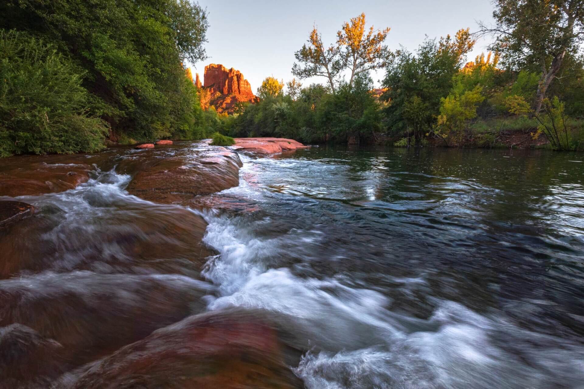
Sedona is a scenic detour that breaks up the Grand Canyon-to-Page drive, but only if you have flexibility in your route — it adds roughly 2 hours of driving time compared to the direct highway north. The town sits at 4,350 feet elevation where red sandstone buttes rise dramatically from a high desert valley, and Oak Creek Canyon (Arizona State Route 89A) is one of the most photographed scenic drives in the region, with pullouts and short walks at nearly every mile.
Best for road trippers who prioritize scenic driving and want to stretch legs on easy trails without committing to a full hike — Sedona delivers postcard-worthy red rock views and a charming walkable town with galleries, restaurants, and shops in a single stop. The single reason it wins: Oak Creek Canyon itself is a natural wonder that rivals any national park drive, and you get it for free.
Logistics: Sedona is roughly 2 hours south of Flagstaff and 2.5 hours southwest of Page. If you’re coming from the Grand Canyon South Rim, you’ll drive south to Williams, then east toward Flagstaff, then south through Oak Creek Canyon to Sedona — this adds significant time.
Most road-trip itineraries skip Sedona if time is tight and head directly north from the Grand Canyon toward Page via U.S. Route 89.
If you do stop, plan 2–4 hours for a scenic drive, a short walk (Cathedral Rock or Devil’s Bridge trailheads are popular), and lunch.
3. Page Area Wonders: Horseshoe Bend, Antelope Canyon, and Lake Powell
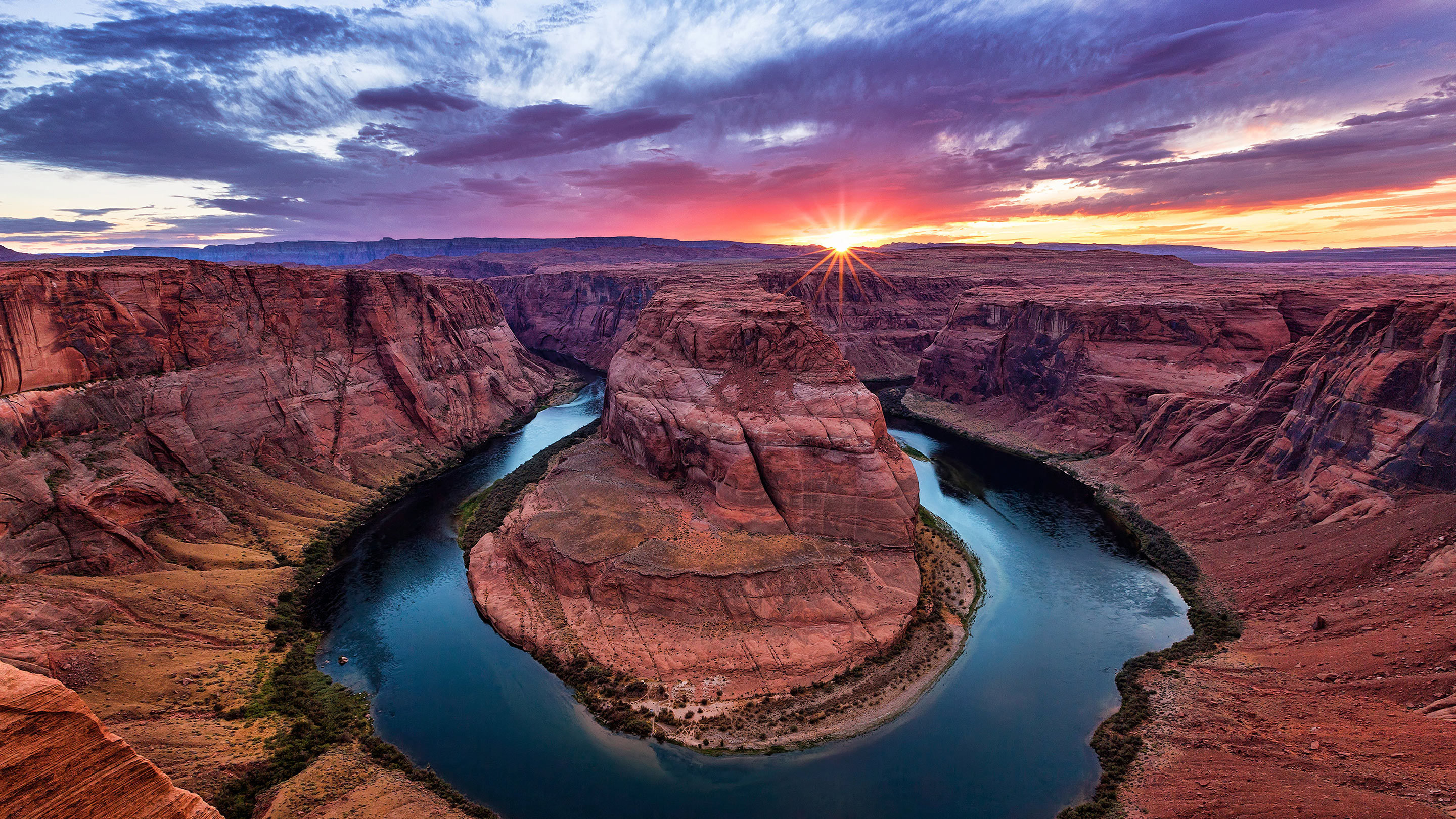
Page, Arizona, is the road-trip sweet spot where three world-class attractions sit within 15 minutes of each other — Horseshoe Bend, Antelope Canyon (Upper and Lower), and Lake Powell — making it possible to experience slot canyons, dramatic river overlooks, and desert water views in a single day without backtracking. This cluster is roughly 2 hours northeast of Flagstaff and 1 hour 58 minutes north of the Grand Canyon South Rim.
Horseshoe Bend is a 1,000-foot river overlook shaped like a horseshoe where the Colorado River makes a dramatic U-turn through red rock walls. Entry is $10 per vehicle, and the site operates sunrise to sunset.
The walk is 1.5 miles round-trip on a sandy, exposed trail with no shade — bring water and sunscreen, and arrive early to beat crowds and heat.
Best for photographers and anyone wanting a dramatic river view without a full hike — the payoff is immediate and the photo is iconic. The single reason it wins: it’s genuinely more massive in person than social media suggests, and the $10 fee is a bargain for the visual impact.
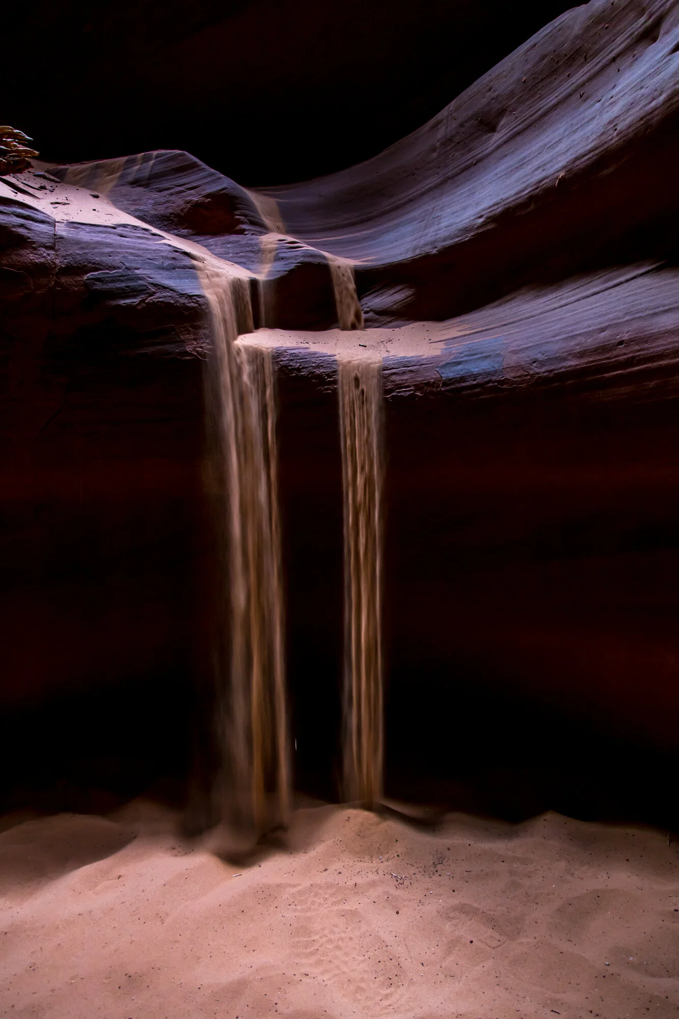
Antelope Canyon is a slot canyon on Navajo land located less than 5 miles from Horseshoe Bend. Entry requires a Navajo permit and a guided tour (no self-guided access).
Upper Antelope Canyon is the more famous slot with light beams and easier access; Lower Antelope Canyon requires climbing ladders but offers more dramatic narrow passages. Permit costs and tour prices vary by operator, typically ranging from $25–$50 for Upper and $30–$60 for Lower, depending on group size and time of day.
Tours run year-round, though summer heat (100°F+) makes early-morning or late-afternoon slots preferable.
Best for anyone wanting to experience a narrow, sculptural canyon with dramatic light and geology — Antelope Canyon is the most photographed slot canyon in the Southwest for good reason. The single reason it wins: the combination of Horseshoe Bend and Antelope Canyon in one day gives you both a wide-open river view and an intimate, enclosed canyon experience without driving more than 10 minutes between them.
Insider detail: Book Upper Antelope Canyon tours for early morning (6–8 a.m.) to catch the famous light beams that filter through the narrow slot; afternoon tours are cheaper but the light is less dramatic. Lower Antelope Canyon is less crowded and offers more dramatic slot formations, but requires physical fitness for ladder climbing.
Lake Powell is a massive reservoir created by the Glen Canyon Dam, offering water recreation, scenic overlooks, and boat tours. Wahweap Marina and Antelope Point Marina are the main access points near Page.
Day-use fees are typically $5–$10 per vehicle; boat rentals and guided tours vary widely in price and availability. The lake is best visited in spring and fall when temperatures are moderate; summer heat can exceed 105°F.
Best for travelers who want water views and optional boat access without committing to a full day of water sports — scenic overlooks and marina walks are free or low-cost. The single reason it wins: it’s a natural break between the intensity of Antelope Canyon and the long drive to Monument Valley, and the water views contrast sharply with the surrounding desert.
Stay and drive logistics: Page is the natural overnight base for this cluster. Hotels and lodges line the main highway; book ahead during peak season (March–October). From Page, Monument Valley is roughly 2.5 hours north via U.S. Route 163.
4. Monument Valley Navajo Tribal Park
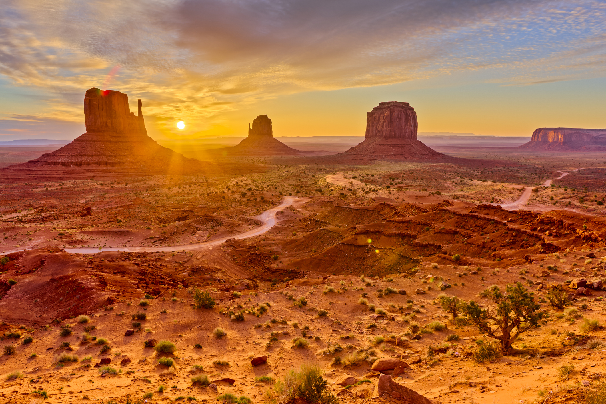
Monument Valley straddles the Arizona-Utah border and is located on Navajo Nation land. The iconic buttes and mesas are instantly recognizable from Western films and photography — this is the landscape that defines the American Southwest in the global imagination.
Entry to the Navajo Tribal Park costs $20 per vehicle (valid for 3 days), and the park is open daily from sunrise to sunset. A 17-mile loop drive with pullouts takes roughly 2 hours; guided tours and horseback rides are available through tribal operators at higher costs.
Best for road trippers who want the most iconic Southwest landscape without hiking — the loop drive delivers constant, dramatic views and is accessible to all fitness levels. The single reason it wins: Monument Valley is the visual climax of an Arizona road trip; no other stop delivers such instantly recognizable, jaw-dropping geology.
Logistics: Monument Valley is roughly 2.5 hours north of Page via U.S. Route 163.
The drive itself is scenic, passing through high desert and Navajo Nation land. The park has limited services; bring water, snacks, and a full tank of gas.
Cell service is spotty. If you’re continuing the road trip into Utah, Monument Valley is a natural jumping-off point to the Navajo Nation, Monument Valley, and southeastern Utah’s canyon country.
Comparison overview: These four Arizona stops represent a north-moving progression from the Grand Canyon’s massive scale, through Sedona’s scenic detour (optional), to Page’s intimate slot canyons and water views, and finally to Monument Valley’s iconic buttes. The drive time between each is 1.5–3 hours, making it feasible to hit all four in 2–3 days if you’re moving quickly, or 4–5 days if you want to hike and explore thoroughly.
Horseshoe Bend and Antelope Canyon are non-negotiable if you have any time at all; Sedona is worth adding only if you enjoy scenic driving and have flexibility; Monument Valley is essential if you want the most recognizable Southwest landscape.
Which Utah National Parks and State Parks are Worth Visiting?
Utah’s red-rock corridor delivers the most dramatic landscape payoff per mile on any Southwest road trip—three national parks and two state parks compressed into a drive that never exceeds two hours between stops, each one visually distinct enough to justify the detour.
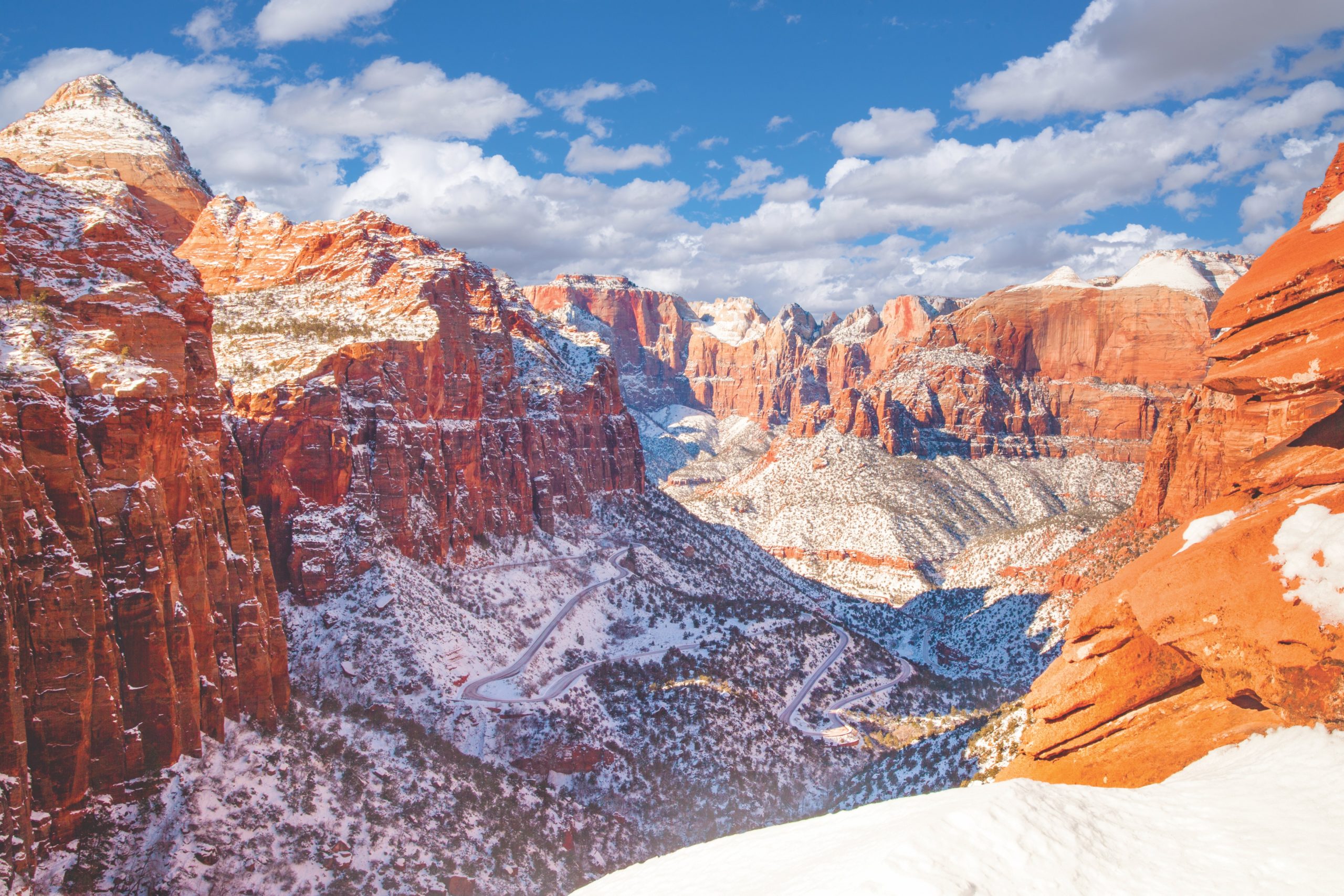
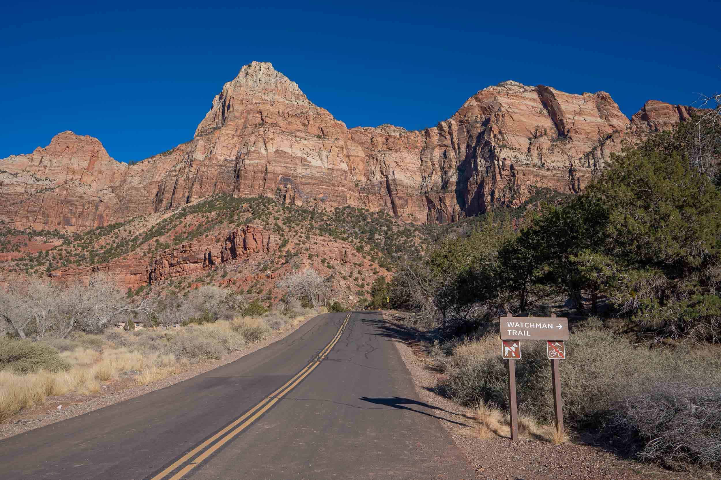
1. Zion National Park
Zion wins for travelers who want the most iconic hike-and-canyon combo without the Grand Canyon’s crowds or distance. The park’s defining feature—towering sandstone cliffs framing the Virgin River—delivers drama in every direction, and the park sits just an hour and 17 minutes from Bryce Canyon, making it a natural road-trip pairing.
Best for: anyone with moderate hiking fitness and a full day to spend. The single reason it wins: the Narrows and Angels Landing trails offer genuine adventure within reach of a casual visitor, unlike many national parks where the best views require backcountry permits or extreme fitness.
Plan to arrive early (before 9 a.m.) to secure parking and avoid the afternoon shuttle-only system that kicks in during peak season. The park operates year-round, but spring and fall offer the best conditions—summer heat can exceed 100°F in the canyon floor.
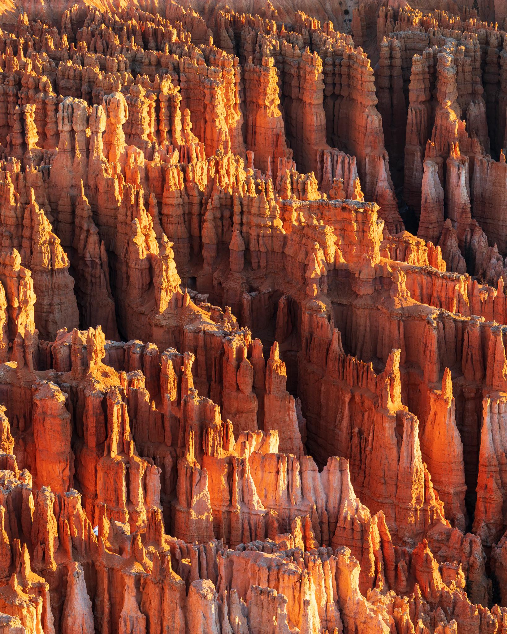
2. Bryce Canyon National Park
Bryce Canyon is not actually a canyon—it’s an amphitheater of red-rock hoodoo formations that look like a fantasy landscape, and it’s the most visually unique stop on this entire road trip. Best for: photographers and anyone who wants to hike *into* a geological formation rather than alongside it.
The single reason it wins: the Navajo Trail descends directly into the hoodoo forest, giving you an intimate, up-close experience with these needle-like spires that no rim-view platform can match.
The Queen’s Garden Trail pairs well with Navajo for a moderate loop, while the Rim Trail works for those preferring a less strenuous walk with panoramic views. Bryce sits at 9,000+ feet elevation, so temperatures run 15–20°F cooler than nearby parks—bring layers even in summer.
The park is open year-round, though winter snow can close some roads temporarily.
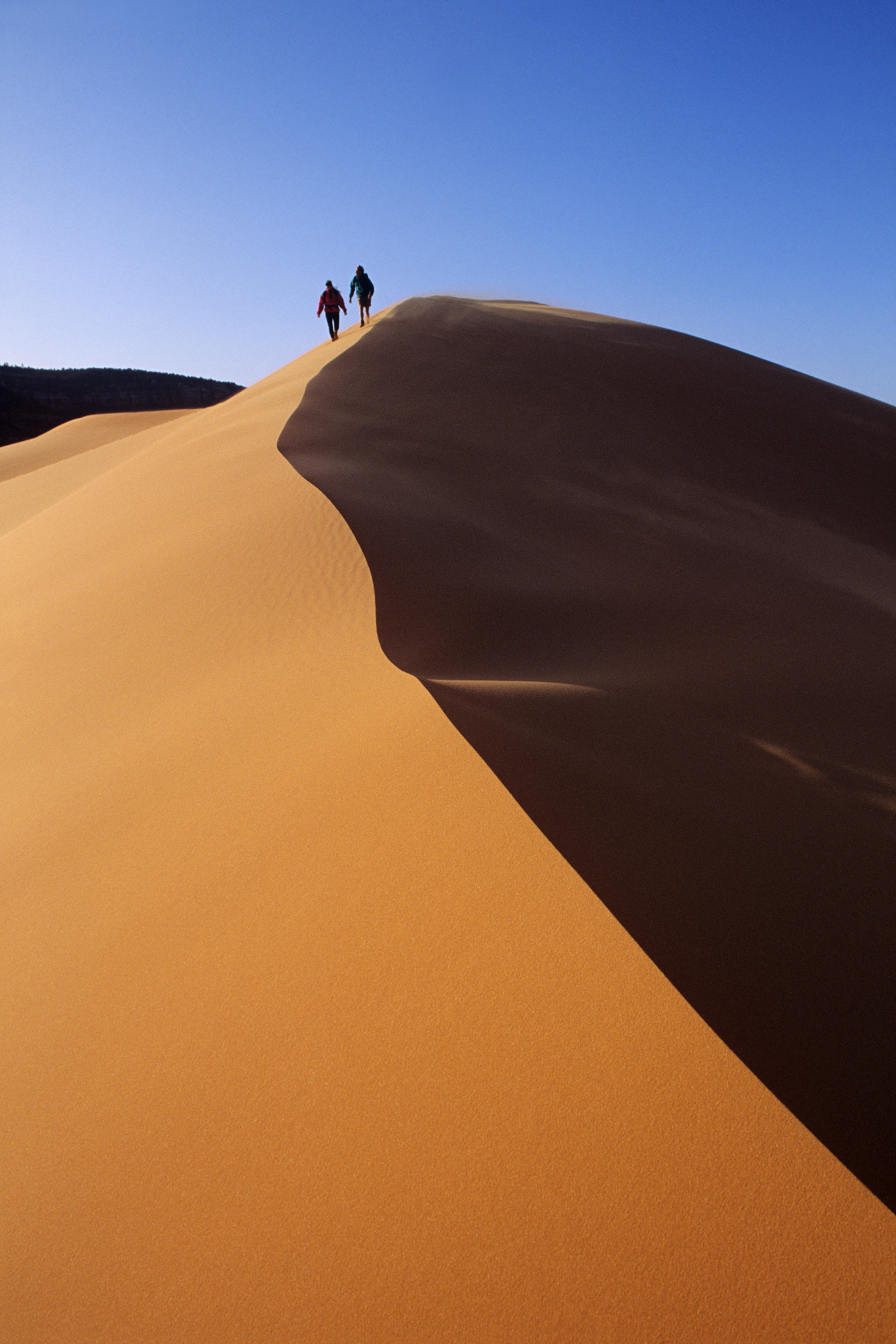
3. Coral Pink Sand Dunes State Park
This 3,700-acre park delivers what Bryce and Zion don’t: a chance to actually *play* in the landscape rather than observe it from a trail. The dunes are soft, walkable, and genuinely fun—you can hike barefoot through warm sand without the technical difficulty of a national park trail.
Best for: families with young kids, anyone wanting a break from serious hiking, and travelers who want to experience desert sand without committing to Death Valley’s extreme heat and distance. The single reason it wins: it’s the only stop on this Utah stretch where you can spend an afternoon doing something other than hiking—sand sledding, dune exploration, and photography all work equally well here.
The park sits between Bryce Canyon and Zion, making it a natural 30–45 minute detour if you’re driving between the two. Camping is available on-site if you want to break up your road trip overnight.
Spring and fall are ideal; summer heat can make the exposed dunes uncomfortable for extended play.
4. Sand Hollow State Park
Sand Hollow is the water-sports outlier in this lineup—a 1,322-acre reservoir ringed by red-rock cliffs where you can fish, boat, dive, or simply cool off after days of desert hiking. Best for: road-trippers who want to break up the hiking routine with water activities, families with non-hiking kids, and anyone needing a genuine rest day.
The single reason it wins: it’s the only stop on the Utah stretch where you can combine desert scenery with actual water recreation, and the blue water against red sandstone makes for stunning photos without requiring a difficult hike.
Located near Hurricane, Utah, Sand Hollow also offers sand dune riding if you want to stay dry. Camping is available, making it a solid overnight stop between Zion and other southern Utah destinations.
Summer is peak season for water activities, though the park operates year-round.
Utah Parks at a Glance
| Park | Best For | Top Activity | Drive Time Between Stops |
|---|---|---|---|
| Zion | Iconic canyon hiking | Angels Landing or Narrows trail | 1 hr 17 min to Bryce |
| Bryce Canyon | Unique hoodoo formations | Navajo Trail descent | 1–1.5 hrs to Coral Pink |
| Coral Pink Sand Dunes | Sand play & casual exploration | Barefoot dune walking | 30–45 min to Zion |
| Sand Hollow | Water activities & rest days | Boating, fishing, or swimming | Variable (near Hurricane) |
Insider tip: Book Zion and Bryce lodging or nearby gateway-town hotels in advance if traveling March–October—both parks fill up quickly, and nearby towns like Springdale (Zion) and Bryce (Bryce Canyon) have limited rooms. Coral Pink and Sand Hollow offer camping as a flexible alternative that doesn’t require advance booking for day-use visits.
Must-See Nevada Stops: From Neon Lights to Natural Wonders
Nevada delivers the Southwest’s most dramatic tonal shift—you can trade slot machines for 150-million-year-old petrified forests and 3,000-foot sandstone walls within an hour of each other, making it essential road trip real estate that rewards both the party-minded and the geology obsessed.
1. Las Vegas Strip and Immersive Attractions

Las Vegas is the road trip’s logical fuel stop and entertainment break, not a detour—it sits directly on most Southwest loops and offers the only urban infrastructure for 100+ miles in any direction. Best for travelers who want a single night of controlled chaos before heading back to nature; skip the multi-day casino crawl and use it as a strategic overnight between Utah parks and Nevada’s natural wonders.
The Strip itself is free to walk, though parking validation at casinos varies by property. Most major hotels offer budget-friendly rooms during weekdays (roughly $40–80) but expect $150+ on weekends and holidays.
The real move for road trippers: stay downtown or on the Strip for one night only, use the morning to grab breakfast and fuel up, then drive straight to Red Rock Canyon or Valley of Fire—both are 30–45 minutes away and will feel like stepping onto another planet.
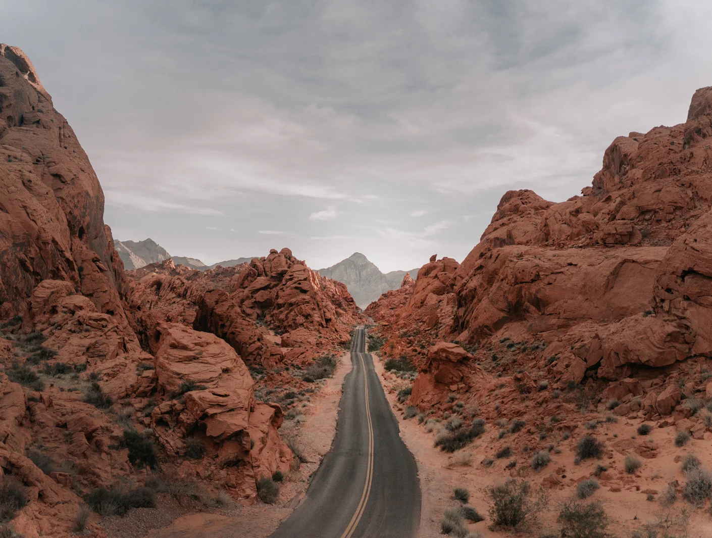
2. Valley of Fire State Park
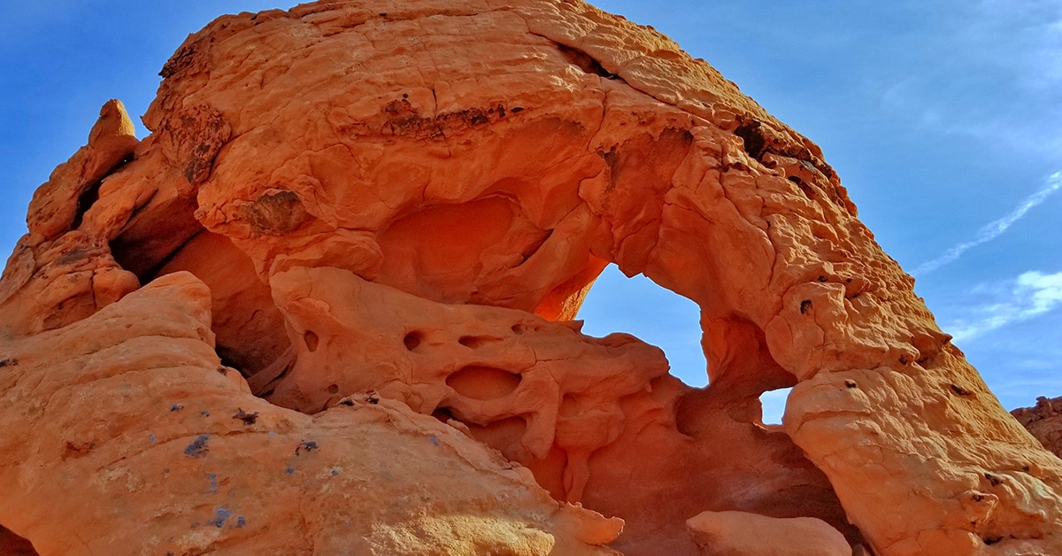
An hour northeast of Las Vegas, Valley of Fire State Park is where you go when red rocks alone aren’t enough—this park layers striped sandstone formations, ancient Native American petroglyphs, and petrified trees from 150 million years ago into a single compact experience that beats most Arizona red-rock fatigue. Best for hikers and photographers who want concentrated visual drama without committing to a full national park day; the entry fee ($20 per vehicle) buys you access to six major trails ranging from 0.3 to 1.5 miles, meaning you can hit multiple hikes in 3–4 hours.
Top hikes by effort and payoff:
- Fire Wave Trail (1.5 miles round trip, easy)—The standout: striped sandstone that genuinely looks like frozen flames, especially at sunset. This is the photo everyone wants.
- White Domes Trail (1.25 miles, easy-moderate)—Slot canyon, contrasting rock colors, and the remains of an old movie set. Expect sand in your shoes; it’s worth it.
- Mouse’s Tank Trail (0.75 miles, easy)—Ancient petroglyphs covering rock walls, ending at a natural rainwater basin. Quick cultural hit without the commitment.
- Atlatl Rock (short metal staircase climb)—Close-up petroglyphs of prehistoric hunting tools. More about cultural history than physical challenge.
- Elephant Rock Trail (0.3 miles, easy)—The park’s most iconic formation, shaped like an elephant. Perfect quick stop if you’re short on time.
Insider tip: Arrive before 10 a.m. to beat the heat and parking crowds, especially May through September. The park has no food, water, or lodging—bring a full cooler and fill up in Las Vegas before the drive.
3. Red Rock Canyon National Conservation Area
Only 30 minutes west of Las Vegas, Red Rock Canyon is the closest natural escape and the most efficient way to see 3,000-foot sandstone walls without leaving the Mojave Desert—a 13-mile scenic loop drive with pullouts, trailheads, and camping that lets you choose between a 20-minute drive-through and a full hiking day. Best for travelers who want dramatic geology without the national park entry fee or reservation hassle; it’s a National Conservation Area, so access is simpler and parking is more forgiving than nearby parks.
The scenic loop is free to drive; parking at trailheads is first-come, first-served. Trails range from 1-mile nature walks to 8+ mile backcountry hikes, so you can calibrate to your energy level.
The loop itself takes 45 minutes to an hour if you stop at 2–3 pullouts; add 2–3 hours if you want to hike. No food or water available inside the park—bring supplies from Las Vegas.
Camping is available at nearby campgrounds (not within the park itself); confirm current availability and reservations before arrival, as capacity and booking windows change seasonally.
4. Hoover Dam Historic Site

Hoover Dam is the road trip’s most efficient historical stop—a 30-minute detour from Las Vegas that delivers engineering spectacle, Colorado River views, and a legitimate photo moment without requiring a full tour or extended time commitment. Best for travelers who want a documented landmark and brief educational context; it’s genuinely impressive as a structure, but the visit itself is 30–45 minutes of walking, viewing, and photo ops, not an all-day event.
Parking is free in the visitor center lot. The dam itself is free to walk across and view from the pedestrian bridge—you get the full visual impact without paying for a tour.
Official dam tours ($15 per person) run throughout the day and take about 30–45 minutes; they’re worth it only if you want interior access and engineering details. The bypass bridge (opened 2010) offers the best photo angles of the dam itself and the Colorado River gorge without entering the dam complex.
Timing: Visit early morning (before 9 a.m.) or late afternoon to avoid tour-bus crowds. The site sits on the Nevada-Arizona border, roughly 45 minutes southeast of Las Vegas on the way to Arizona parks, making it a natural waypoint rather than a backtrack.
Nevada road trip flow: Overnight in Las Vegas, fuel and breakfast, drive to Red Rock Canyon (30 min) for a morning hike or scenic loop, continue to Valley of Fire (1 hour from Red Rock) for afternoon trails, or reverse the order depending on your Arizona-to-Utah routing. Hoover Dam works as a quick stop on the way into Arizona if you’re heading toward the Grand Canyon or Flagstaff next.
Top California Desert and Eastern Sierra Stops
The California desert and Eastern Sierra stretch the Southwest road trip into raw, otherworldly terrain where you’ll find the lowest point in North America, alien-shaped rock formations, and geothermal pools that feel like secret finds — but only if you time them right and know where to stop.
1. Death Valley National Park
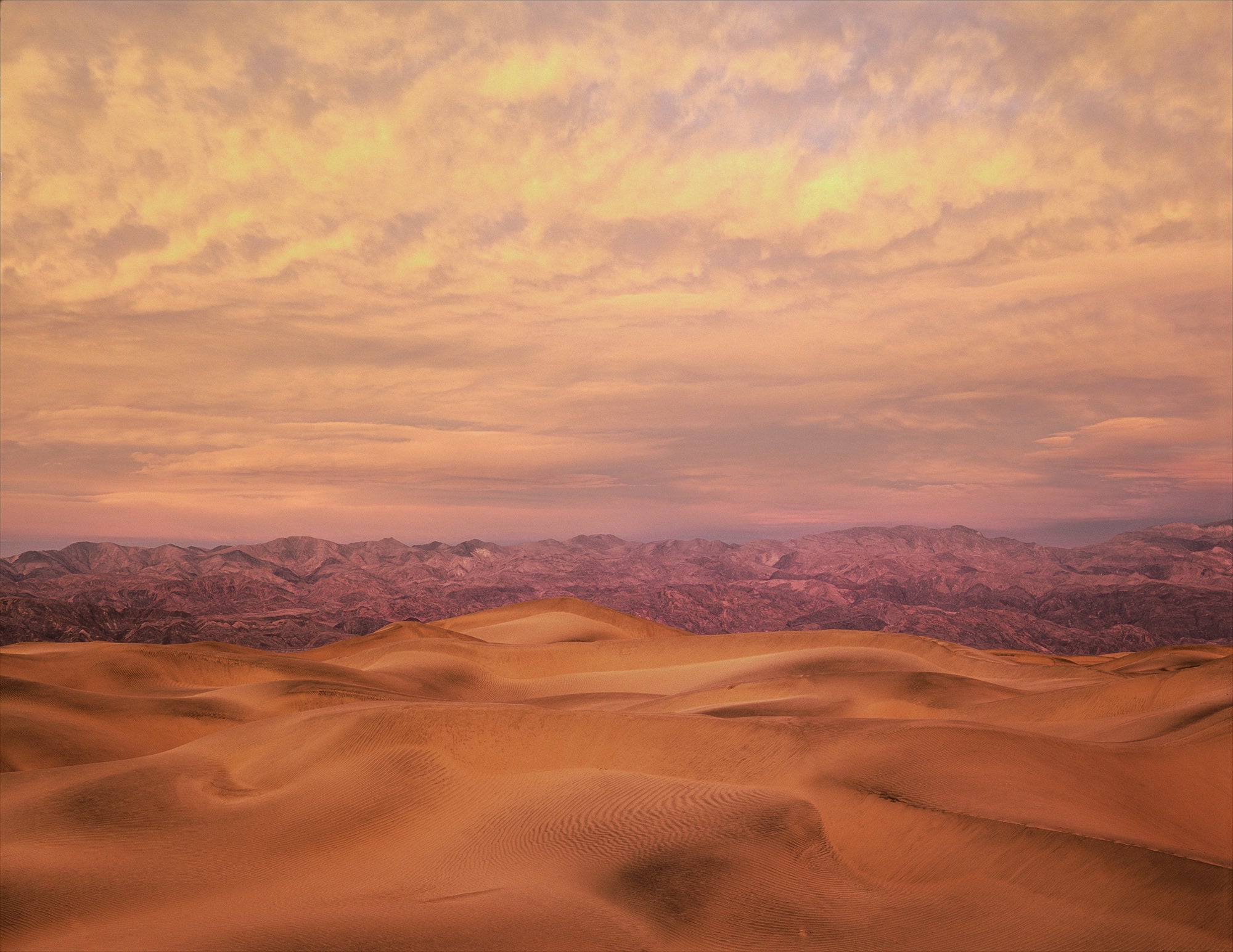
Death Valley spans 3,000 square miles across California and Nevada and holds the title of lowest, hottest, and driest national park in the country — the landscape genuinely feels like another planet. The park’s most accessible draw is Mesquite Flat Sand Dunes, where you can run barefoot across warm sand and watch light shift across badlands and salt flats.
This stop wins for road-trippers who want dramatic desert scenery without technical hiking, though the heat is punishing outside late fall through early spring.
Timing matters here more than almost anywhere on this route. Plan Death Valley visits between late fall and early spring to avoid heat advisories that make midday driving dangerous. The park is less crowded during off-season months, and camping spots open up significantly.
If you arrive in summer, you’ll face closures and unsafe conditions — skip it entirely rather than push through.
Base yourself in nearby gateway towns with lodging options, or camp within the park if you’re equipped. The drive through the valley is the experience itself; allow a full day to stop at Artist’s Palette (multicolored mineral-stained hillsides) and Badwater Basin (the lowest point at 282 feet below sea level) without rushing.
2. Joshua Tree National Park and Twentynine Palms
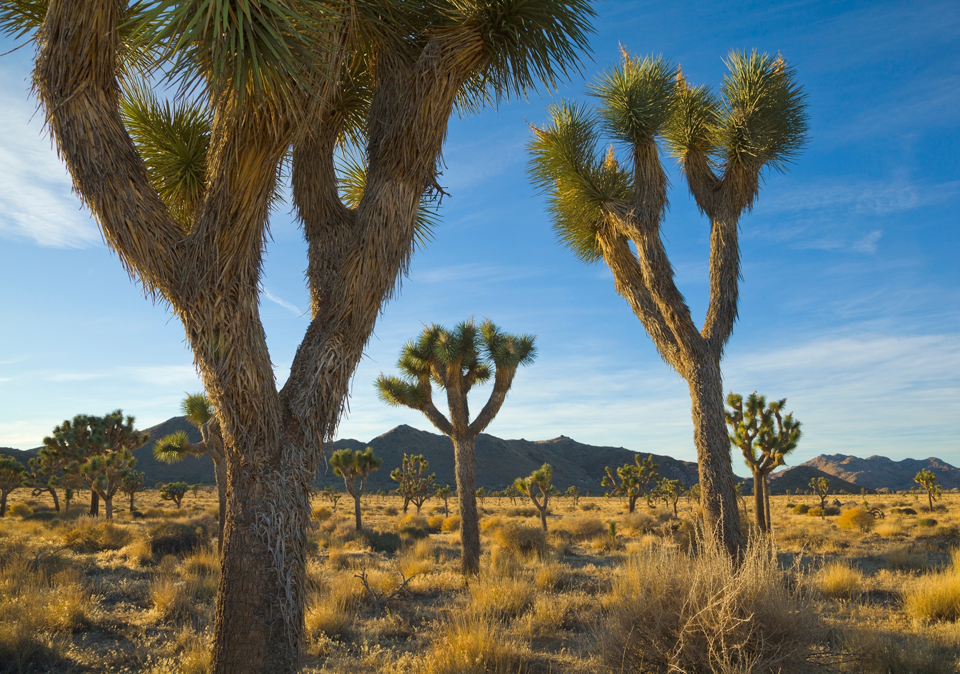
Joshua Tree National Park sits where the Mojave Desert meets the Colorado Desert, and the park’s signature twisted Joshua trees frame boulder-studded plains and rock formations that rival any climbing destination in the Southwest. This stop is best for road-trippers who want to combine desert scenery with actual hiking — the park has everything from easy desert walks to serious rock scrambles.
The town of Twentynine Palms at the park’s base offers public art, stargazing opportunities, and lodging ranging from desert motels to RV parks and vacation rentals, making it an easy overnight base.
The park entrance fee is included in the America the Beautiful Annual Pass (if you’re using one for other national parks on this trip), or expect roughly $30 per vehicle for a seven-day pass. Plan at least a half-day here; full-day visitors should prioritize the best hikes rather than trying to see everything.
Arrive early to secure parking at popular trailheads, especially on weekends.
3. Eastern Sierra Geothermal Pools: Travertine and Wild Willy’s Hot Springs
The Eastern Sierra’s geothermal pools offer a completely different desert experience — soaking in naturally heated water surrounded by stark mountain and desert views. Travertine Hot Springs and Wild Willy’s Hot Springs are the two standout stops for road-trippers who want to break up driving with a soak and a photo moment.
Travertine Hot Springs features cascading mineral-deposited pools stacked like natural bathtubs; Wild Willy’s is smaller, more remote, and less crowded if you’re avoiding peak times.
Both are free and accessible year-round, though winter access can be weather-dependent — confirm conditions before driving out. Arrive early morning or late afternoon to avoid crowds and get the best light for photos.
Bring a towel and water shoes (the mineral deposits are sharp). These stops work best as a break between Joshua Tree and Death Valley, adding roughly 1–2 hours to your route but delivering an experience you can’t replicate elsewhere on a Southwest road trip.
4. Alabama Hills and Movie Road
Alabama Hills is a compact desert range famous as a filming location for Westerns and sci-fi movies — the otherworldly rock formations and wide-open plains explain why. This stop is ideal for photographers and anyone who wants dramatic desert scenery without a long hike or park entrance fee.
Movie Road winds through the hills and passes filming locations; a short drive takes you past iconic backdrops in under an hour.
The area is free to explore and open year-round. Arrive in late afternoon when light hits the rocks at the best angle for photos.
This is a quick stop (30 minutes to 1.5 hours) that fits naturally between Joshua Tree and Death Valley without adding significant drive time.
5. Mojave Desert Lava Tube
The Mojave Desert Lava Tube is a genuinely unique stop — a collapsed volcanic tunnel where light beams pierce through openings and illuminate the cave interior in ways that feel almost supernatural. This is the most off-the-beaten-path stop on this section, and arriving early means you might be alone for most of your visit.
The light beams are best in late morning through early afternoon, though weather and sun angle shift the effect daily, so there’s no guaranteed perfect shot.
The site is free and accessible year-round, but it’s remote — confirm road conditions before heading out, especially in winter. Plan 1–2 hours here including drive time from the main highway.
This stop rewards early planners and photographers willing to venture slightly off-route; casual road-trippers might skip it in favor of more accessible desert stops.
Comparison overview: Death Valley demands a full day and specific seasonal timing but delivers the most dramatic desert landscape. Joshua Tree pairs well with Twentynine Palms for lodging and hiking variety.
The geothermal pools (Travertine and Wild Willy’s) are quick, free soaks best used as driving breaks. Alabama Hills is a 30-minute photo stop.
The Lava Tube rewards early arrivals and photographers but requires flexibility on light and weather.
Where Should You Camp and Stay Along the Road Trip Route?
Free camping sites and budget-friendly overnight stops are the real game-changer for a Southwest road trip—they let you spend money on experiences instead of lodging. The desert has abundant free and low-cost camping options scattered between major parks, but you need to know where to look and book strategically to avoid arriving somewhere full or closed.
For route-friendly overnight bases, Las Vegas works as your western anchor (about 2.5 hours from Zion), while small gateway towns near each park cluster—Springdale near Zion, Kanab near Bryce, Fredonia near the North Rim area—offer a mix of camping, budget hotels, and Airbnb options. The key is staying close enough to your next morning’s trailhead to start early, which means you’ll want to overnight near each major park rather than driving long distances between them.
Free and Low-Cost Camping Options
Use freecampsites.net and TheDyrt.com to find dispersed camping and developed campgrounds before you leave home. Freecampsites.net lists Bureau of Land Management (BLM) sites and dispersed areas where camping is free or under $15 per night—these are scattered throughout Arizona, Utah, Nevada, and California near the parks you’re visiting.
TheDyrt focuses on developed campgrounds with amenities (water, toilets, sometimes hookups) and lets you book ahead, which matters during peak season (March through October) when popular sites fill fast.
The insider move: arrive at free BLM sites mid-week or early in the day, not Friday evening. Popular dispersed areas near Zion, Bryce, and Monument Valley get crowded on weekends, and you may find no available spots.
Confirm access roads are open before driving to remote sites—winter closures and flash flood damage can block routes without warning.
Gateway Towns and Overnight Stops by Region
Arizona (Grand Canyon, Sedona, Monument Valley): Flagstaff is the largest hub with the most lodging variety, about 80 miles south of the Grand Canyon South Rim. For closer overnight access to the rim, Tusayan (just outside the park) has budget motels and RV parks.
Sedona offers upscale resorts and boutique inns but comes with premium pricing; Williams, 30 miles west, gives you Route 66 charm and cheaper beds if you’re willing to drive an extra 45 minutes to the rim. For Monument Valley, Kayenta or Mexican Hat (Utah side) are your only real options—both are small, basic towns with limited lodging, so book ahead or plan to camp.
Utah (Zion, Bryce, Cedar Breaks): Springdale sits directly at Zion’s south entrance and is walkable, with restaurants and shops, but lodging runs $120–$200+ per night during peak season. For budget camping, BLM sites line the Virgin River approach roads.
Bryce Canyon has a National Park Service campground inside the park (book at recreation.gov) with sites around $25–$30 per night; Panguitch and Tropic are small towns 30–45 minutes away with cheaper motels. Kanab, about 45 minutes from Bryce, is a quieter alternative with local character and lower prices.
Nevada (Las Vegas, Valley of Fire, Red Rock Canyon): Las Vegas is your major overnight stop and has every lodging type imaginable, though Strip hotels can run $100–$300+ per night depending on day of week and season. For camping near Red Rock Canyon and Valley of Fire, BLM sites and the Valley of Fire State Park campground ($20–$25 per night) put you 45 minutes to an hour from Vegas.
Avoid staying on the Strip if you’re road-tripping on a budget; downtown or off-Strip casinos offer cheaper rooms, and you’ll save time driving in and out of the main tourist corridor.
California (Death Valley, Eastern Sierra, Alabama Hills): Death Valley has two NPS campgrounds (Furnace Creek and Sunset) that book months ahead and run $25–$36 per night; free BLM camping exists outside the park boundary. Lone Pine, near Alabama Hills and the Eastern Sierra gateway, has budget motels and is a solid overnight stop before heading to Death Valley or Travertine Hot Springs.
Furnace Creek Resort inside the park offers the only full-service lodging option but costs $150–$300+ per night and books far in advance.
Camping and Lodging Comparison by Trip Priority
| Priority | Best Stay Style | Cost Range | Best For |
|---|---|---|---|
| Budget maximizer | Free/low-cost BLM dispersed camping | $0–$15/night | Travelers with a camper van or tent who want to spend $30–$50 total on lodging for the entire trip |
| Comfort + savings | NPS campgrounds inside parks | $25–$36/night | Groups or families who want amenities (toilets, water, sometimes showers) and park proximity without resort pricing |
| Convenience + budget | Gateway town motels (Kanab, Williams, Panguitch) | $70–$120/night | Road-trippers who prefer a bed and shower but don’t want Vegas or Sedona prices; willing to drive 30–45 minutes to parks |
| Walkable base | Boutique inns or hotels (Springdale, Sedona) | $120–$250+/night | Couples or small groups who want restaurants, shops, and nightlife within walking distance and don’t mind premium pricing |
Booking Strategy and Timing
Book NPS campgrounds 4–6 months ahead via recreation.gov if traveling March through October; sites fill within hours of opening for reservations. For gateway town hotels, book 2–4 weeks ahead during peak season.
Free BLM sites don’t require reservations, but arrive by mid-afternoon to claim a spot, especially Thursday through Sunday. If you’re traveling in winter (November through February), lodging is cheaper and less crowded, but confirm park roads and campgrounds are open—some close seasonally or due to weather.
The single best move: base yourself in one town for 2–3 nights rather than moving every night. This cuts packing/unpacking time, lets you explore one park deeply, and often qualifies you for multi-night discounts at motels and Airbnbs.
Springdale for Zion, Kanab for Bryce and the Escalante area, and Lone Pine for Death Valley and the Eastern Sierra are the strongest overnight anchors.
Is the America the Beautiful National Parks Pass Worth It?

The $80 Annual National Parks Pass pays for itself in roughly two park visits—and on a Southwest road trip hitting multiple parks across four states, it becomes the single smartest financial decision you’ll make before leaving home.
Here’s the math: Grand Canyon alone costs $35 per vehicle. Zion runs $35 per car.
Without the pass, you’re looking at $35–$40 per park entrance, plus parking fees that can add another $40 per day at popular sites. The pass covers admission to every national park in the U.S. for 12 months, which means unlimited entries to Grand Canyon, Zion, Bryce Canyon, Death Valley, and any other park you visit during your trip—and beyond.
The pass does NOT cover Monument Valley Navajo Tribal Park ($20 per vehicle), which operates independently and doesn’t accept the Annual Pass. But that’s the only major stop on this itinerary that won’t be covered.
For a typical 7–10 day Southwest road trip hitting 4–5 national parks, the pass saves $100–$200 compared to paying per-park entrance fees. If you’re planning to return to the Southwest or visit any other national parks within a year, the math is even more compelling.
Buy it before you leave home—you can purchase online at recreation.gov or at any park entrance, though buying ahead saves time at busy gates during peak season.
Skip the pass only if you’re visiting just one park and have no plans to return to any U.S. national park within the next year. Otherwise, it’s non-negotiable.
Frequently Asked Questions
How long should a Southwest road trip be?
A meaningful Southwest road trip covering Arizona, Utah, Nevada, and California typically takes 7–10 days minimum. This gives you two full days per state to hit major stops without constant driving.
Shorter trips (3–5 days) force you to choose: either focus on one state deeply or accept 6+ hours of driving daily with minimal time at each location. Longer trips (two weeks or more) let you add Eastern Sierra stops, slot canyons, and smaller parks without sacrificing sleep or hiking time.
What’s the best route to avoid backtracking?
Start in Las Vegas, drive northeast to Zion and Bryce Canyon in Utah, head east to Monument Valley on the Arizona-Utah border, drop south through Arizona’s parks (Grand Canyon, Sedona), then loop west through Nevada’s Valley of Fire and Red Rock Canyon before returning to Vegas. This creates a logical loop.
Alternatively, reverse it if you’re flying into Phoenix. The key mistake: trying to hit Death Valley and Joshua Tree on the same trip unless you have 12+ days—they add 4+ hours of driving in opposite directions and break your flow.
Do I need a National Parks Pass, or should I pay per park?
Buy the Annual Pass ($80) if you’re visiting three or more parks—it pays for itself immediately. Zion alone costs $35 per car; Bryce Canyon is $35; Grand Canyon is $35.
A typical Southwest loop hits 4–6 parks, so the pass saves $50–$130. The pass also covers parking at most parks, though some (like Zion) charge separately for shuttle parking ($40/day).
If you’re doing only two parks, skip the pass and pay per entry.
Where should I stay to keep costs down without sacrificing sleep?
Free camping is your best move for budget road trips. Search freecampsites.net and TheDyrt.com for dispersed camping near trailheads and parks—many spots are genuinely free and offer better solitude than paid campgrounds.
Base yourself in gateway towns (Springdale near Zion, Kanab near Bryce, Sedona, Moab) where you can grab one paid night for laundry, showers, and a real bed, then camp the rest. Airbnb works for couples who want a private space; budget campgrounds ($15–$30/night) are fine if you don’t mind crowds.
Avoid staying directly in Las Vegas or Phoenix unless you’re spending a full day there—the drive from Vegas to Zion is 2.5 hours, so you’ll waste morning time getting out of the city.
Start Your Southwest Road Trip With Confidence
Book your first night in Las Vegas or Flagstaff, download offline maps to your phone before you lose cell service, and pack at least one gallon of water per person per day—these three moves eliminate 90% of road trip stress before you even leave home.
The Southwest rewards travelers who show up prepared but flexible. Weather shifts, roads close, and the best light for photography happens when you’re not expecting it—but that’s exactly what makes this road trip worth doing instead of watching someone else’s photos online.
Reserve your lodging and campgrounds now, grab the America the Beautiful Pass, and plan to arrive at your first major park by mid-morning—you’ll have the entire afternoon to hike, explore, and understand why this landscape has been calling people here for generations.
Leave a Reply