The smell of pine and dust hits you first as you crest a mountain pass in early August, the kind of moment that makes you understand why people abandon their lives for the open road. Late summer is when the West’s high-elevation trails finally shed their snow, when coastal fog burns off by mid-morning, and when you can actually breathe in the mountains without fighting July’s brutal heat or September’s leaf-peeping gridlock.
August road trips demand a different strategy than spring travel—fire season closures, wildlife activity, and peak crowds are real—but they reward planning with something spring cannot deliver: genuinely comfortable driving temperatures in places that matter. The difference between a smooth August trip and a frustrating one comes down to choosing routes that actually stay cool and understanding which parks require reservations months in advance.
This guide cuts through the noise and gives you five Western routes, three Midwest escapes, four Eastern drives, and three Canadian options worth the border crossing—each tested for August viability, crowd reality, and actual weather comfort. Budget ranges from $800–$2,000 for a week-long trip (lodging, gas, park fees) depending on route and comfort level; splurge options push toward $3,000+ with nicer hotels and guided experiences.
Your August Road Trip Quick Reference
Western Routes (Peak Alpine Season): The Volcanic Legacy Byway (400 miles, 2–3 days) delivers dramatic geology without Yellowstone crowds; the Pacific Coast Highway (656–1,326 miles, 5–7 days) offers iconic coastal stops; the Northern Cascades Loop (300 miles, 3–4 days) combines mountains and rainforest; Glacier to Stanley (800 miles, 5–7 days) targets serious backpackers; Route 66 (2,300 miles or sections, 5–14 days) demands commitment but rewards with Americana.
Midwest Escapes (Coolest Temps): The Great Lakes Circle Tour (12–14 hours driving, 2 days) features rare carnivorous plants and island isolation; Badlands to Black Hills (8–10 hours, 2 days) delivers multicolored rock formations and bison; Lake Superior’s North Shore (2.5–3 hours, 2–3 days) prioritizes waterfalls and kayaking.
Eastern Routes (Pre-Fall Crowds): The Blue Ridge Parkway (469 miles, 3–5 days) earns its “America’s Favorite Drive” title; New England peaks to Acadia (4–6 days) stacks mountains and coastal cliffs; Upstate New York Adirondacks (5–7 days) offer wilderness without crowds; North Carolina High Country (3–5 days) suits hikers and mountain bikers.
Canadian Options (Fewer Crowds, Stable Weather): The Golden Circle through Yukon and Alaska (300 miles, 4–5 days) is genuinely remote; the Icefields Parkway (144 miles, 6–8 hours) delivers postcard glaciers; Prince Edward Island (three coastal loops, 4–5 days) emphasizes charm and seafood.
Critical August Planning Rules: Book lodging 4–6 weeks ahead (mid-August fills fast); download offline maps before leaving (cell service fails in parks); arrive at popular overlooks before 8 a.m. (parking fills by 9 a.m.); confirm park roads are open 24 hours before arrival (fire closures happen without warning); carry a physical road atlas (not nostalgia, insurance).
What Are the Best Late Summer Road Trips in the Western USA?
August in the West means alpine wildflowers still blooming, high-elevation trails finally snow-free, and coastal fog burning off by mid-morning—but it also means booking your overnight stops now or driving 90 minutes past your preferred town. The five routes below are ordered geographically from north to south, so you can chain them together or pick one and commit.
1. The Volcanic Legacy Byway: Redwoods National Park to Crater Lake
This nearly 400-mile drive through Northern California and southern Oregon is the move if you want dramatic geology without the crowds of Yellowstone. Start in Redwoods National Park (coastal access, old-growth forest), then drive inland to Shasta-Trinity National Forest and Mt.
Shasta, California’s fifth-largest peak and an actual stratovolcano. The real payoff is the Volcanic Scenic Legacy Byway itself—a stunning stretch connecting Mt.
Shasta to Crater Lake National Park, passing Burney Mountain and Medicine Lake Volcano. The road forces you to slow down; take it.
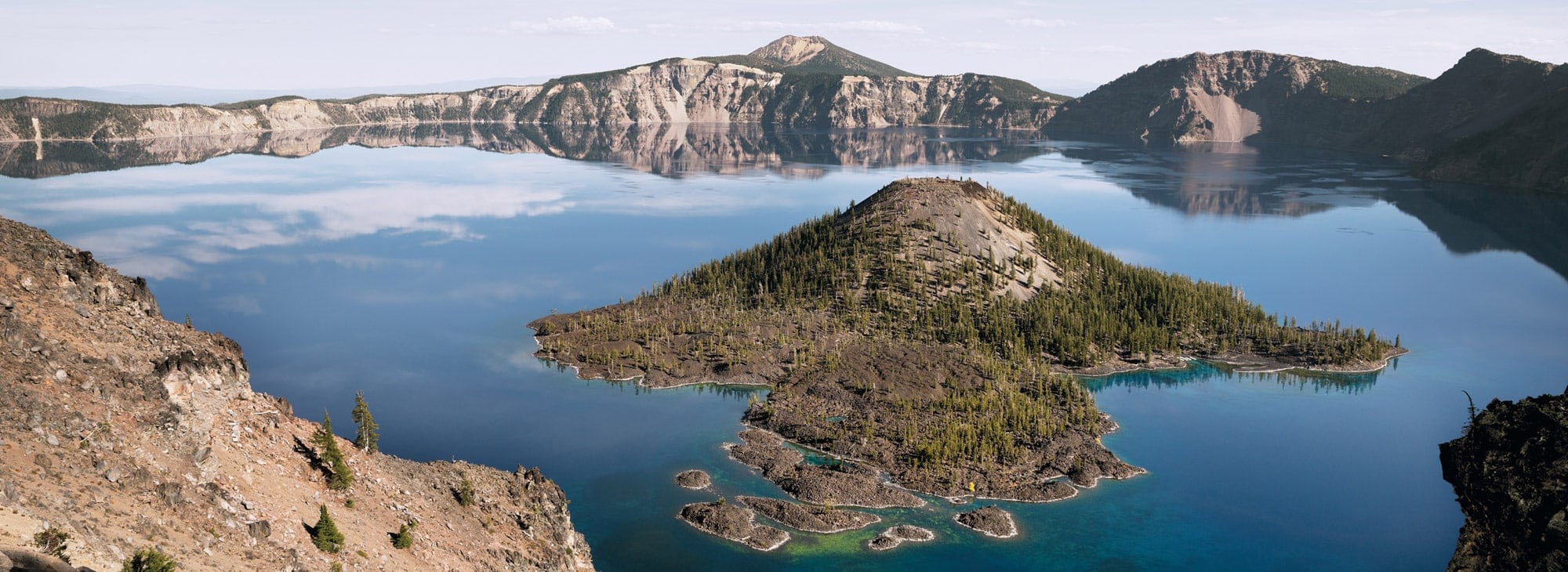
Crater Lake is the endpoint and the reason to do this drive: impossibly deep blue water, 1,900 feet of caldera walls, and the Watchman Peak Trail (short but steep) delivering the full panorama. August is ideal because snow clears the high-elevation roads and trails by early month, though confirm current conditions with the park before you go—early-season closures still happen.
- Best for: Geology nerds, photographers, anyone who wants dramatic scenery without fighting summer peak crowds.
- Drive time: Roughly 8–10 hours total (spread over 2–3 days to actually stop and hike).
- Where to stay: Base yourself in Klamath Falls, Oregon (gateway town near Crater Lake) or Redding, California (near Mt. Shasta and Shasta-Trinity trailheads). Both offer route-friendly hotels and quick morning access to the park entrances.
- Insider detail: Spend at least one full day at Crater Lake—the lake reveals different moods depending on light and time of day, and the rim drive (33 miles) is best done early morning before afternoon clouds roll in.
2. The Pacific Coast Highway: Iconic Coastal Views from California to Washington
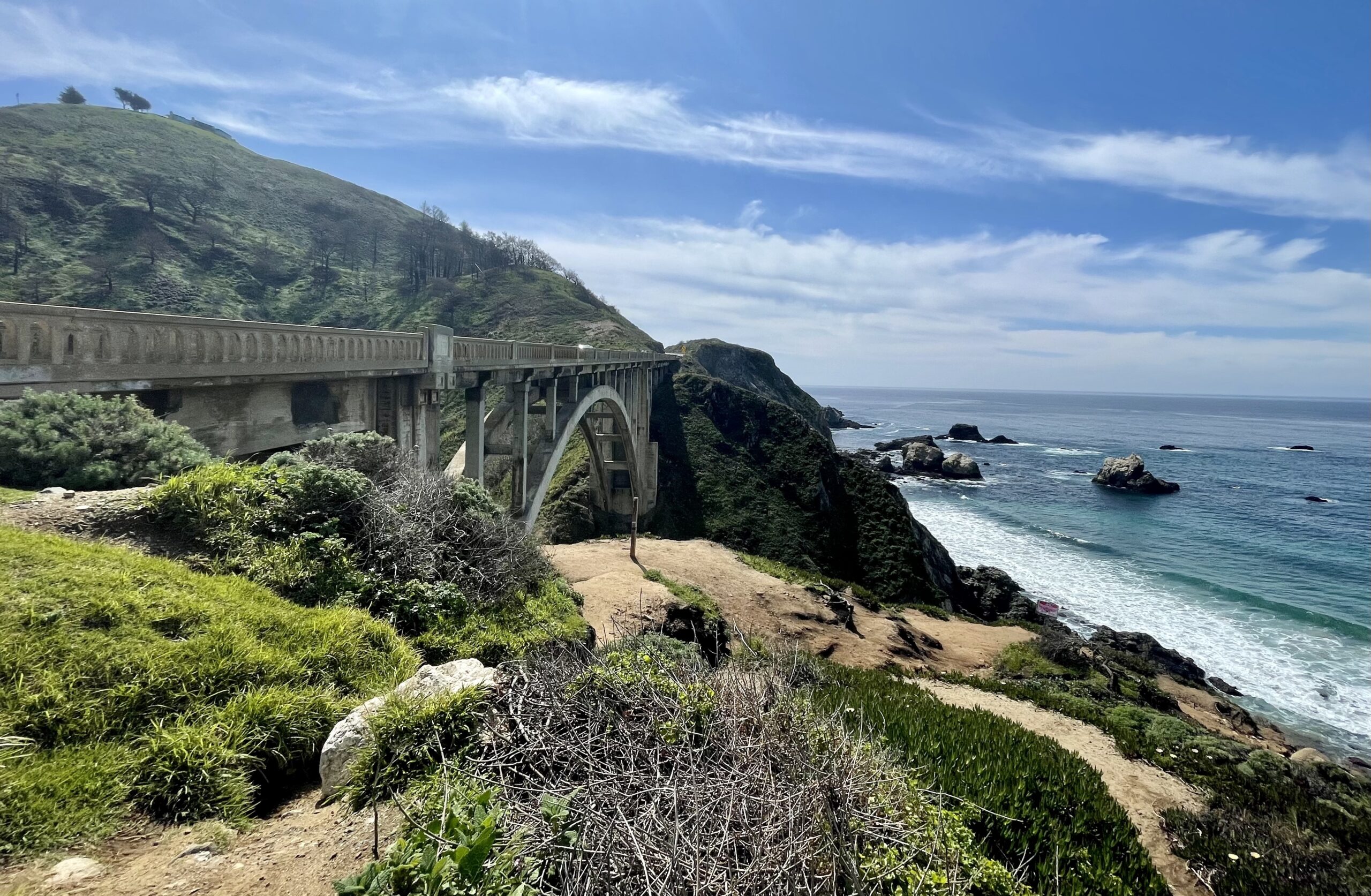
The Pacific Coast Highway (Highway 1) is one of the world’s most famous coastal drives for a reason: 656 miles from Southern California through Northern California’s redwoods, then another 670 miles north through Oregon and Washington to Seattle. August is the sweet spot—fog burns off by mid-morning, water is coldest (keeping crowds lighter than July), and wildflower season is still active in coastal bluffs.
The California stretch delivers the iconic Instagram moments: Big Sur cliffs, Hearst Castle views, Malibu beaches. The Oregon and Washington extension is the smarter move if you want fewer cars and better food—Dungeness crab, wild salmon, and oysters dominate local menus, and small coastal towns like Cannon Beach and Yachats are far less mobbed than California’s famous stops.
- Best for: Coastal lovers, photographers, road-trippers who want a single iconic drive without backtracking.
- Drive time: 656 miles (California alone) takes 10–12 hours of driving; 1,326 miles total (California to Seattle) is a 5–7 day trip if you actually stop.
- Where to stay: Overnight in coastal towns along the route—Carmel-by-the-Sea or Big Sur (California), Cannon Beach (Oregon), or Port Townsend (Washington). Beach rentals and waterfront hotels let you wake to ocean views and avoid backtracking inland.
- Insider detail: Drive the California section northbound (south to north) so the ocean is on your right and you can pull over easily; the reverse direction means crossing traffic to reach viewpoints.
3. The Northern Cascades and Olympic Peninsula Wilderness Loop
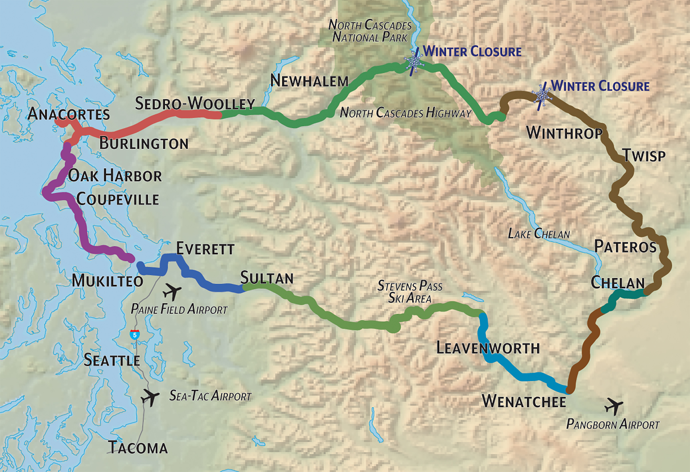
This 300-mile loop through Washington State combines two of the Pacific Northwest’s most dramatic drives: the North Cascades Highway (State Route 20) and the Olympic Peninsula loop. August is the only month when the North Cascades Highway is fully open and snow-free at high elevations—it closes by November and doesn’t reopen until late April, making late summer your window.
The North Cascades Highway delivers alpine lakes, jagged peaks, and glacier views without requiring a national park entrance fee. From there, loop west to the Olympic Peninsula for temperate rainforest, coastal beaches, and the quieter side of Pacific Northwest tourism.
This is a road trip for hikers and nature photographers who want wilderness without fighting Yellowstone-level crowds.
- Best for: Hikers, photographers, anyone who wants dramatic mountain scenery plus old-growth forest and coastal access in one loop.
- Drive time: Roughly 300 miles over 3–4 days (the drive itself is 6–8 hours, but you’ll want multiple days for trailheads and stops).
- Where to stay: Base yourself in Sedro-Woolley or Concrete, Washington (gateway towns on the North Cascades Highway) or Port Angeles (Olympic Peninsula gateway). Both offer route-friendly lodging and early-morning access to trailheads.
- Insider detail: The North Cascades Highway closes seasonally—confirm it’s open before you book; early August is safest, as late-season snow can still force closures.
4. The High Rockies Adventure: Glacier National Park to Stanley, Idaho
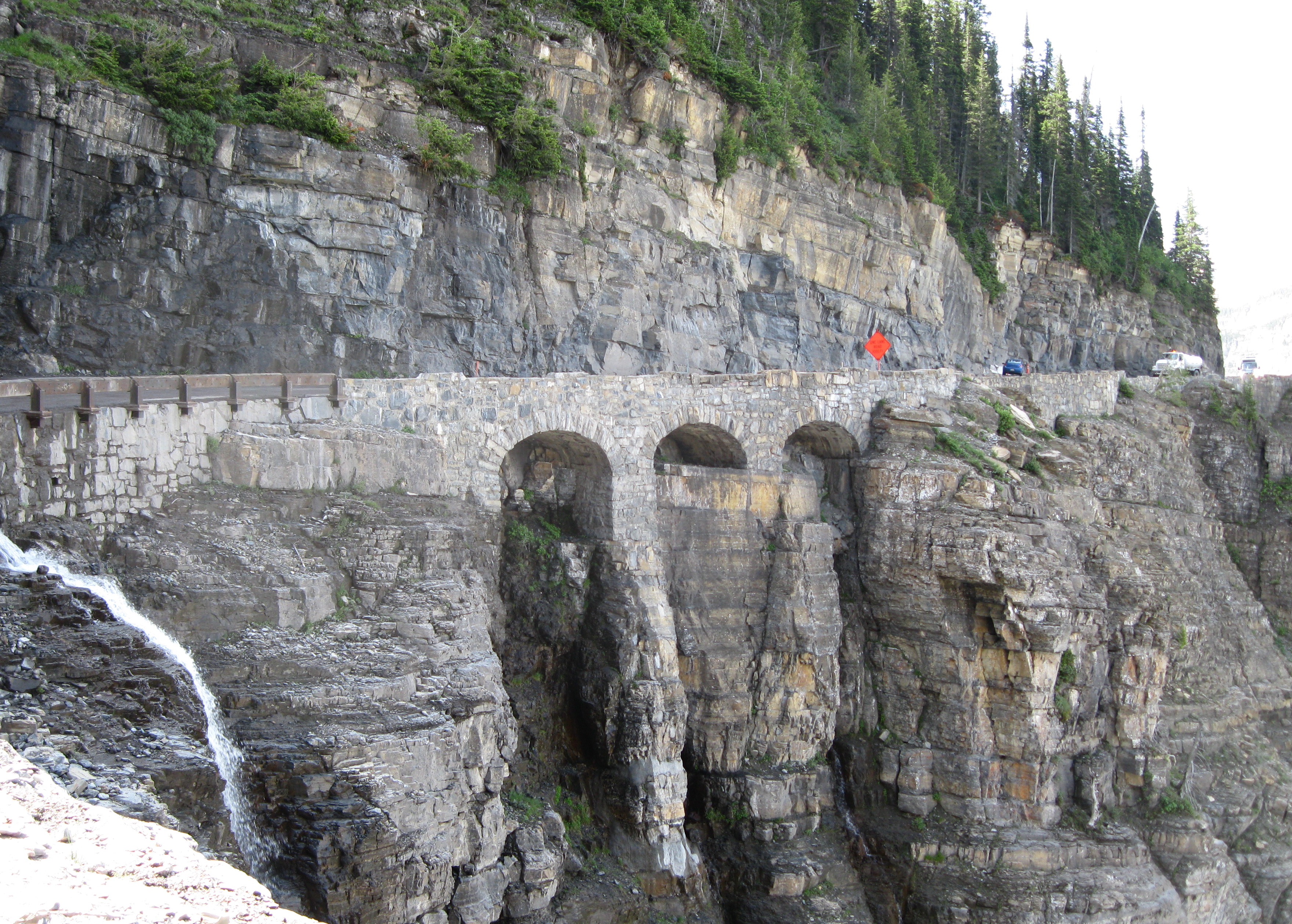
Nearly 800 miles of pure outdoor paradise from Glacier National Park (Montana) to Stanley, Idaho—this is the route for anyone who wants to spend an entire summer here and still barely scratch the surface. August is prime season: high-elevation trails are snow-free, wildflowers are blooming, and the weather is stable enough for multi-day backpacking trips.
Glacier National Park anchors the north end with the Going-to-the-Sun Road (50 miles of switchbacks and alpine views). From there, drive south through the Bob Marshall Wilderness complex and into central Idaho’s backcountry, finishing at Stanley—a tiny mountain town surrounded by the Sawtooth Mountains and pristine alpine lakes.
This is a route for serious outdoor enthusiasts, not casual scenic drivers.
- Best for: Backpackers, mountaineers, fly fishers, and anyone who prioritizes wilderness access over creature comforts.
- Drive time: Roughly 12–15 hours of driving spread over 5–7 days (the drive is secondary to the hiking and camping).
- Where to stay: Overnight in gateway towns like Kalispell, Montana (near Glacier’s west entrance) or McCall, Idaho (central route stop). Cabins, mountain lodges, and campgrounds dominate the landscape—expect rustic comfort, not luxury hotels.
- Insider detail: The Going-to-the-Sun Road is one-way during peak season in some sections—check current traffic patterns before you go, and drive it early morning to avoid afternoon congestion and afternoon thunderstorms.
5. Route 66: Driving the “Mother Road” from Chicago to Los Angeles
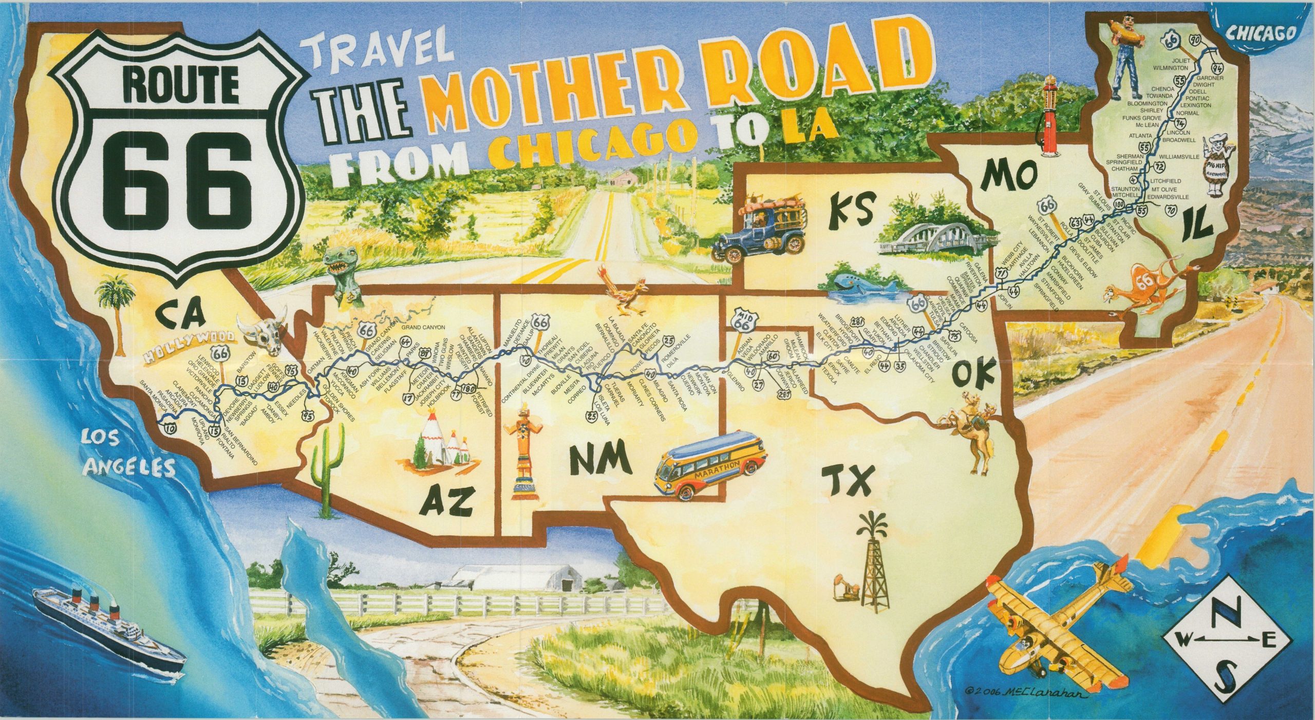
Route 66 set the standard for American road trips and spans 2,300 miles from Chicago to Los Angeles—the longest route on this list and the one that demands the most time. August heat in the Southwest (Arizona, New Mexico, Oklahoma, Texas) can exceed 100°F, making early morning and evening driving essential, but the iconic diners, vintage motels, and small-town Americana are worth the discomfort.
This is not a scenic-drive-in-one-week trip. Most travelers tackle sections of Route 66 rather than the full 2,300 miles.
A realistic August itinerary covers Chicago to the Texas Panhandle (roughly 1,200 miles, 5–7 days) or focuses on the Southwest section (Arizona and New Mexico, 3–4 days). The route passes through dozens of small towns where the real Route 66 experience lives—vintage gas stations, hand-painted signs, family-run restaurants that have been operating since the 1950s.
- Best for: Americana enthusiasts, vintage culture lovers, anyone who wants a road trip with serious historical weight and quirky stops.
- Drive time: 2,300 miles total; most travelers do 1,200–1,500 miles (5–10 days) rather than the full route.
- Where to stay: Overnight in historic Route 66 towns—Seligman, Arizona; Williams, Arizona; Albuquerque, New Mexico; Amarillo, Texas. Vintage motels and small-town inns are part of the experience; skip chain hotels if possible.
- Insider detail: August is brutally hot in the Southwest—plan to drive early morning (5–7 a.m. starts), stop during peak heat (11 a.m.–4 p.m.), and resume in late afternoon. Pack extra water, check your car’s AC before you go, and fill up gas in small towns where pumps are sparse.
Quick Comparison: Which Route Fits Your August Trip?
| Route | Best For | Drive Time | Ideal Days | August Advantage |
|---|---|---|---|---|
| Volcanic Legacy Byway | Geology, photography | 8–10 hours | 2–3 | High-elevation roads snow-free |
| Pacific Coast Highway | Coastal scenery, iconic stops | 656–1,326 miles | 5–7 | Fog burns off, fewer crowds than July |
| North Cascades Loop | Hiking, rainforest, mountains | 300 miles | 3–4 | Highway only open June–October |
| Glacier to Stanley | Backpacking, wilderness | 800 miles | 5–7 | Trails snow-free, wildflowers blooming |
| Route 66 | Americana, vintage culture | 2,300 miles (or sections) | 5–14 | Iconic stops accessible; heat requires early starts |
The honest take: Pick based on how many days you have and what you actually want to do. The Volcanic Legacy Byway and North Cascades Loop are weekend-friendly (2–4 days).
The Pacific Coast Highway and Glacier-to-Stanley routes need a full week. Route 66 is a commitment—most people do a section, not the whole thing.
Book overnight stops now if you’re traveling the first two weeks of August; availability tightens fast.
Which Mid-Country Routes Offer the Coolest Weather in August?
August in the Midwest and Upper Great Lakes is your escape hatch from the scorching South and crowded coasts—these three routes keep temperatures 10–20°F cooler than the national average while delivering genuine natural drama: rare carnivorous plants, multicolored badlands, and Superior’s dramatic shoreline. All three are drivable in 4–6 days, hit peak wildflower and waterfall season, and avoid the worst summer crowds because most travelers don’t think to head inland.
6. The Great Lakes Circle Tour: Indiana Dunes to the Apostle Islands
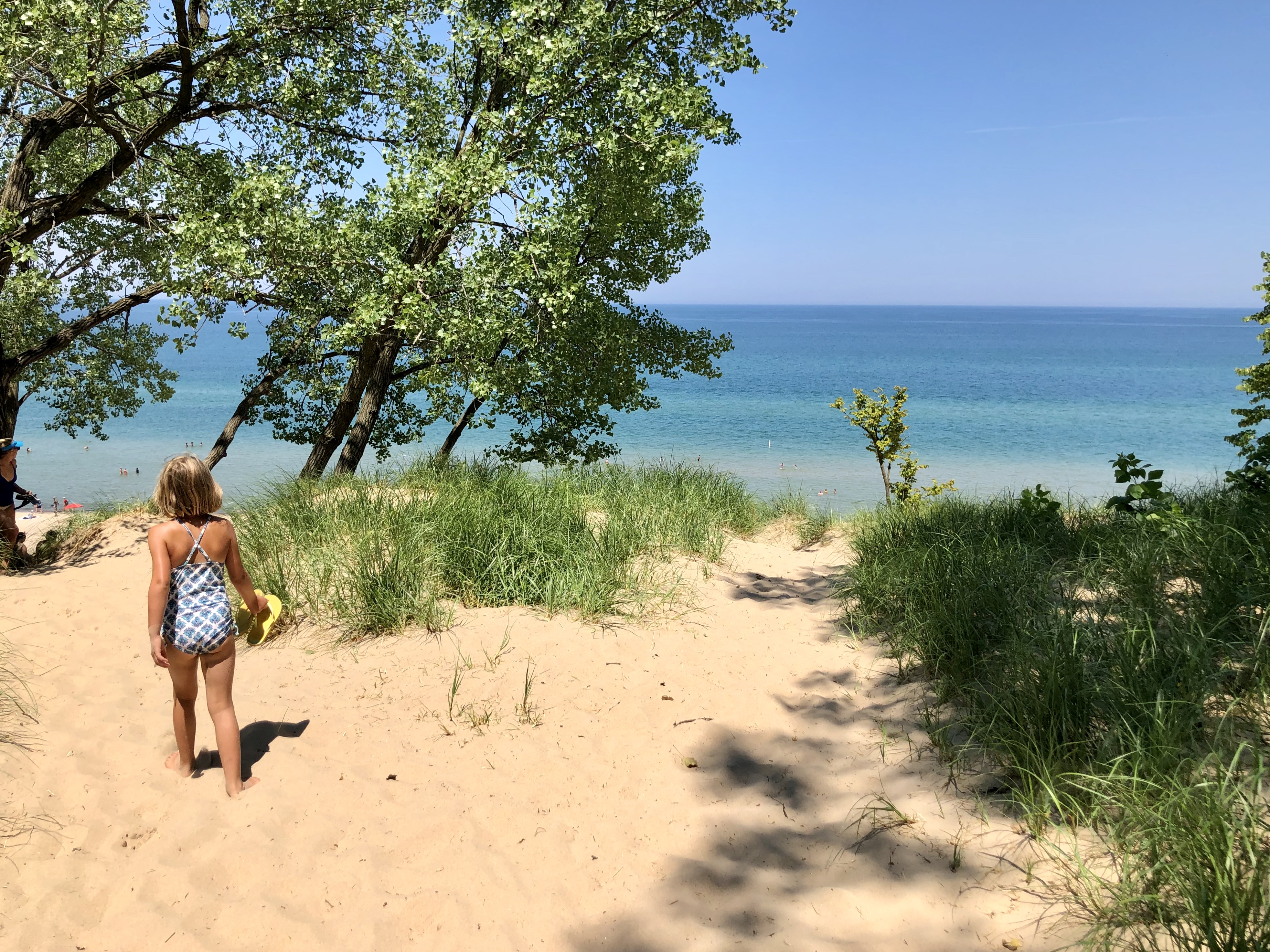
Start at Indiana Dunes National Park on Lake Michigan’s southern shore—15,000 acres packed with over 1,000 plant species, including ghost pipe (a rare white parasitic plant) and multiple carnivorous species thriving in the same small footprint. This isn’t just beach lounging; the biodiverse ecosystems here are genuinely unusual for the Midwest.
Spend a morning hiking the dune trails, then drive north into Michigan’s Upper Peninsula.
Stop in Marquette, the largest UP city, to break up the drive and grab supplies before heading to Lake Superior’s north shore. The real payoff: the Apostle Islands, a cluster of 22 islands off Bayfield, Wisconsin.
August water temps hover around 55–60°F (still cold, but swimmable for the committed), and the islands offer sea caves, lighthouses, and isolation that feels like the Canadian North without crossing the border. Base yourself in Bayfield, a quiet Victorian-era town with easy ferry access to the islands and walkable downtown restaurants and galleries.
- Best for: Hikers and nature photographers who want biodiverse ecosystems without desert heat.
- Driving time: Roughly 12–14 hours total from Indiana Dunes to Bayfield; break it into two days with an overnight in Marquette.
- Insider move: Book island ferry tours in advance (typically $30–50 per person); the most dramatic sea caves fill up by mid-August.
- August advantage: Water is calmest, wildflowers peak, and crowds thin after the first week.
7. South Dakota’s Hidden Gems: Badlands National Park to the Black Hills
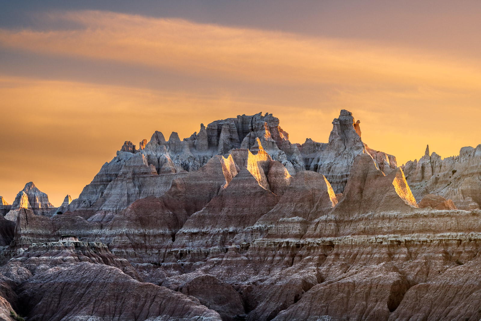
The Badlands deliver the most visually striking August drive in the mid-country: 244,000 acres of striped, multicolored rock formations that shift from cream to rust to deep purple depending on light and weather. August temps average 75–80°F during the day (20+ degrees cooler than the Southwest), and the dramatic erosion gullies and fossil beds stay accessible when other regions bake.
The drive from the park’s northeast entrance to the southwest exit spans roughly 30 miles of pure geological theater.
From the Badlands, head west into the Black Hills to explore granite peaks, ponderosa pine forests, and the famous Mount Rushmore area. The Black Hills offer genuine cooler relief—elevations reach 7,000+ feet, dropping temps another 10–15°F.
Custer State Park, adjacent to Mount Rushmore, is the move for anyone wanting to avoid the monument’s crowds while still experiencing the region’s iconic landscape; the park’s 18-mile Wildlife Loop Road offers bison, elk, and prairie dog colonies without the tourist machinery.
- Best for: Road-trippers who want dramatic scenery and hiking without desert heat or coastal fog.
- Driving time: Roughly 8–10 hours from Badlands to Black Hills; easily split into two days with an overnight in Wall, South Dakota (a quirky roadside town with the famous Wall Drug store).
- Insider move: Drive the Badlands Loop Road at sunrise or late afternoon when light hits the formations at the sharpest angle; midday glare flattens the colors.
- August advantage: Wildflowers bloom through early August; bison are most active in cooler early mornings.
8. The North Shore Scenic Drive: Lake Superior’s Minnesota Coastline
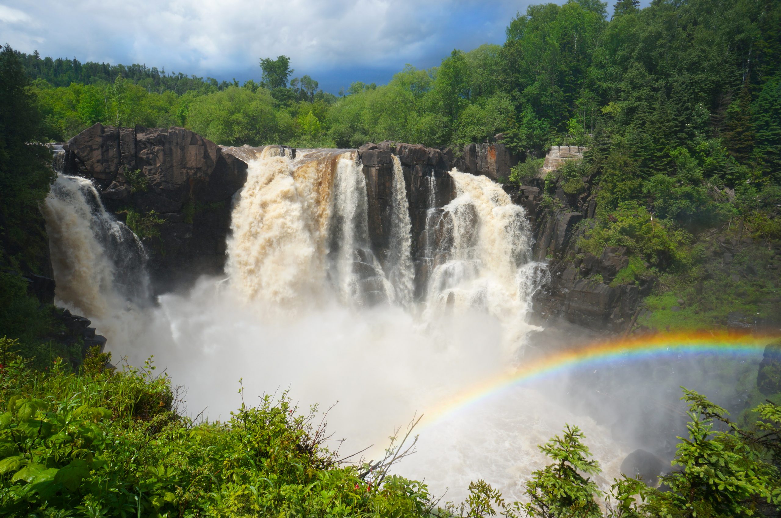
This is the shortest route (roughly 150 miles from Duluth to the Canadian border) but the most water-focused: you’re hugging Lake Superior’s northwest shoreline the entire drive, with dramatic coastal cliffs and waterfalls dropping directly toward the water. August temps stay in the 65–70°F range, making this the coolest of the three routes and the best choice for anyone who wants to escape heat entirely.
Eight Minnesota State Parks line the drive, anchored by Gooseberry Falls—a showstopper with multiple cascades tumbling over rocky ledges into Lake Superior.
Base yourself in Duluth (the gateway) or Tofte/Grand Marais (midway points) for easy access to trailheads and waterfront dining. The drive is straightforward and scenic enough that you can cover it in a single day, but the real move is to spend 2–3 days exploring the state parks, hiking to waterfalls, and kayaking in the calm bays.
August water temps are around 50–55°F—cold enough to require a wetsuit for serious swimming, but perfect for kayaking and wading.
- Best for: Waterfall chasers and kayakers who want dramatic geology without backpacking.
- Driving time: 2.5–3 hours end-to-end; plan 2–3 days to actually explore the parks and falls.
- Insider move: Hike to waterfalls early (before 9 a.m.) to avoid crowds and catch the best light; Gooseberry Falls gets packed by midday.
- August advantage: Water is calmest for kayaking; wildflowers and ferns peak; bugs are fewer than July.
Comparison: Which Route Wins for Your Trip?
| Route | Best For | Coolest Temps | Driving Time | Peak Activity |
|---|---|---|---|---|
| Great Lakes Circle | Rare ecosystems, island exploration | 65–70°F | 12–14 hours (2 days) | Ferry tours, sea caves |
| Badlands to Black Hills | Geology, wildlife, dramatic scenery | 75–80°F (Black Hills cooler) | 8–10 hours (2 days) | Sunrise drives, bison spotting |
| North Shore Superior | Waterfalls, kayaking, water-focused | 65–70°F | 2.5–3 hours (2–3 days to explore) | Waterfall hikes, kayaking |
The verdict: Pick the North Shore if you want the shortest drive and most dramatic water access; pick the Great Lakes Circle if you want the most unique ecosystems and island isolation; pick Badlands to Black Hills if you want the most iconic scenery and don’t mind slightly warmer temps in exchange for visual impact.
Top Late Summer Road Trips in the Eastern USA and Appalachia
August in the East means cooler mountain air, fewer families on school breaks, and the sweet spot before leaf-peepers clog every overlook in September. These four routes deliver the scenery that made the region famous—without the gridlock of peak season or the brutal heat of July.
9. The Blue Ridge Parkway: “America’s Favorite Drive” from Shenandoah to the Smokies
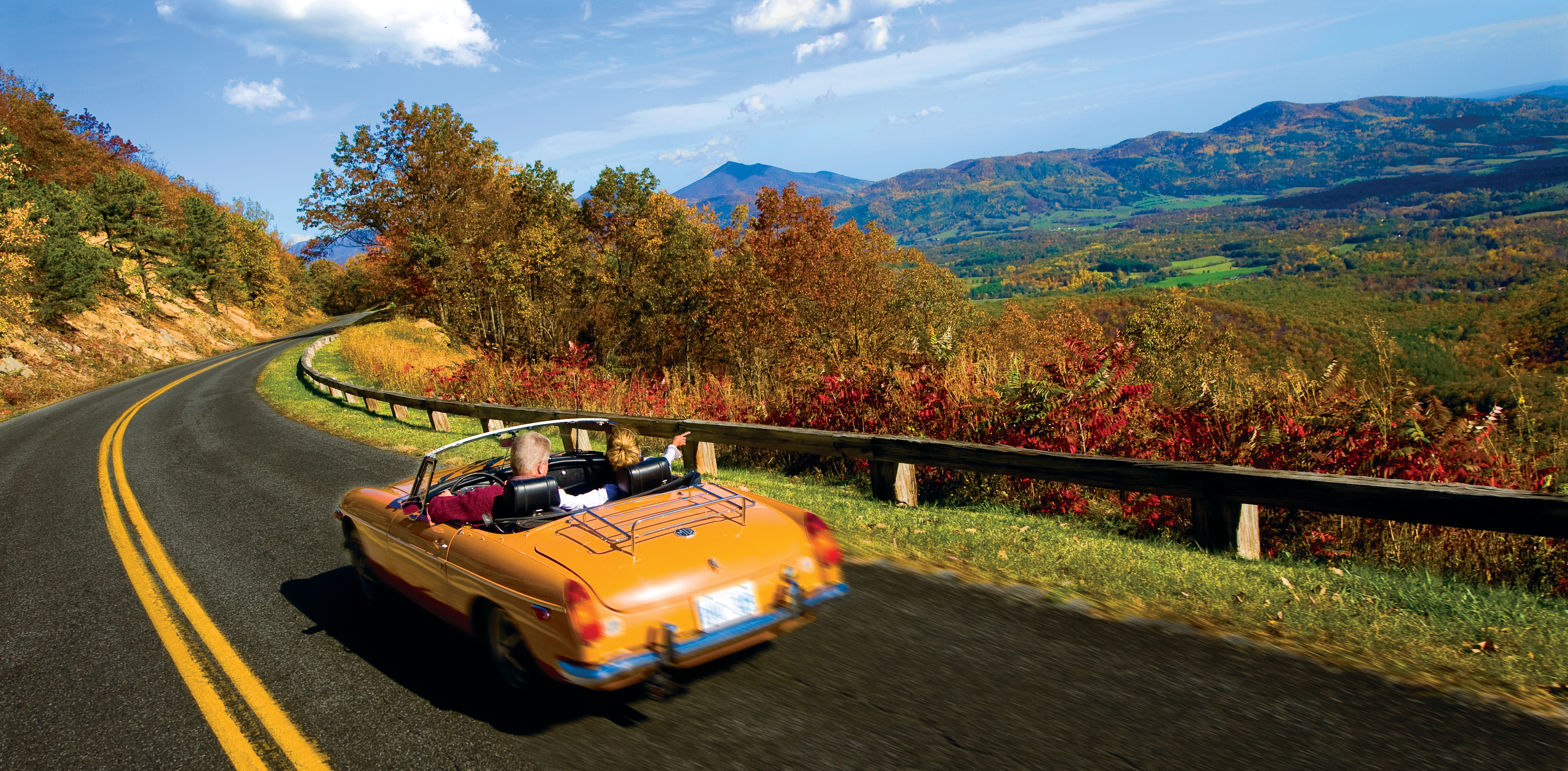
The Blue Ridge Parkway earns its nickname as “America’s Favorite Drive” for one reason: 469 miles of unbroken mountain vistas with zero commercial traffic. This isn’t a highway—it’s a slow, deliberate crawl through the Appalachian spine, and August is when you can actually enjoy it without fighting fall-foliage crowds that arrive in September.
The route connects Shenandoah National Park in Virginia to Great Smoky Mountains National Park in North Carolina. You control the start and end point, so base yourself in a gateway town like Asheville, North Carolina (central to both parks and packed with restaurants and breweries) or Waynesboro, Virginia (closer to Shenandoah’s northern entrance).
The drive itself takes roughly 10–12 hours of actual driving time, but the point is to spend 3–5 days crawling it, stopping at overlooks, short hikes, and the occasional roadside waterfall.
- Best for: Couples, photographers, and anyone who wants scenery without the adrenaline sports.
- August advantage: Fewer crowds than fall, cooler temps than July, and wildflowers still blooming at higher elevations.
- Insider move: Stop at overlooks during the golden hour (late afternoon) when the light hits the ridgelines—the same view at noon is flat and washed out.
- Plan for: Gas up before entering the parkway; services are sparse. Bring a physical map or download offline maps—cell coverage is unreliable.
The parkway itself has no entrance fee, but Shenandoah and Great Smoky Mountains both charge park fees (typically $30 per vehicle for a week-long pass). Expect roughly 2–3 hours of actual hiking if you want to break up the drive, or skip the trails entirely and just drive and photograph.
10. The New England Coast and Peaks: White Mountains to Acadia National Park
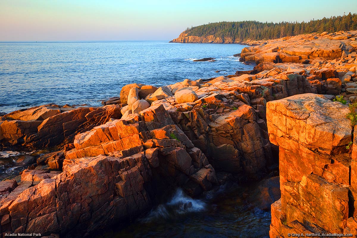
This route stacks two entirely different landscapes—the jagged granite peaks of New Hampshire’s White Mountains and the rocky Maine coast—into one unforgettable loop. August is the only month when you get reliable weather, warm water for swimming, and the lobster shacks are fully staffed.
Start in the White Mountains (base yourself in North Conway or Franconia Notch for easy access to trailheads and roadside diners), then drive northeast toward the coast. The final destination is Acadia National Park, where the real payoff happens: Cadillac Mountain’s sunrise, which requires a $6 parking pass during high season and an alarm set for 3:30 am.
Yes, it’s brutal. Yes, it’s worth it—you’ll catch the first sunrise in the continental United States from a 1,530-foot peak overlooking the Atlantic.
Bring a headlamp to avoid tripping on rocks in the dark.
- Best for: Active travelers who want both hiking and coastal scenery in one trip.
- Cadillac Mountain sunrise reality: Arrive by 5 am to secure parking; the lot fills fast even in August. The view is genuinely stunning, but manage expectations—you’re standing with 200 other people.
- Alternative if sunrise feels too ambitious: Drive Cadillac Mountain Road during the day (no reservation needed) and hike one of Acadia’s easier trails like Jordan Pond Path instead.
- Lobster strategy: Skip the tourist traps in Bar Harbor; drive 20 minutes south to quieter coastal towns where locals eat.
Acadia charges a $30 per-vehicle park fee (or $55 for an annual pass). White Mountain National Forest has no entrance fee, but parking at popular trailheads costs $5–$6 per day. Plan for 4–6 days to do this route justice without feeling rushed.
11. Upstate New York Escapes: Exploring the Adirondacks and Finger Lakes
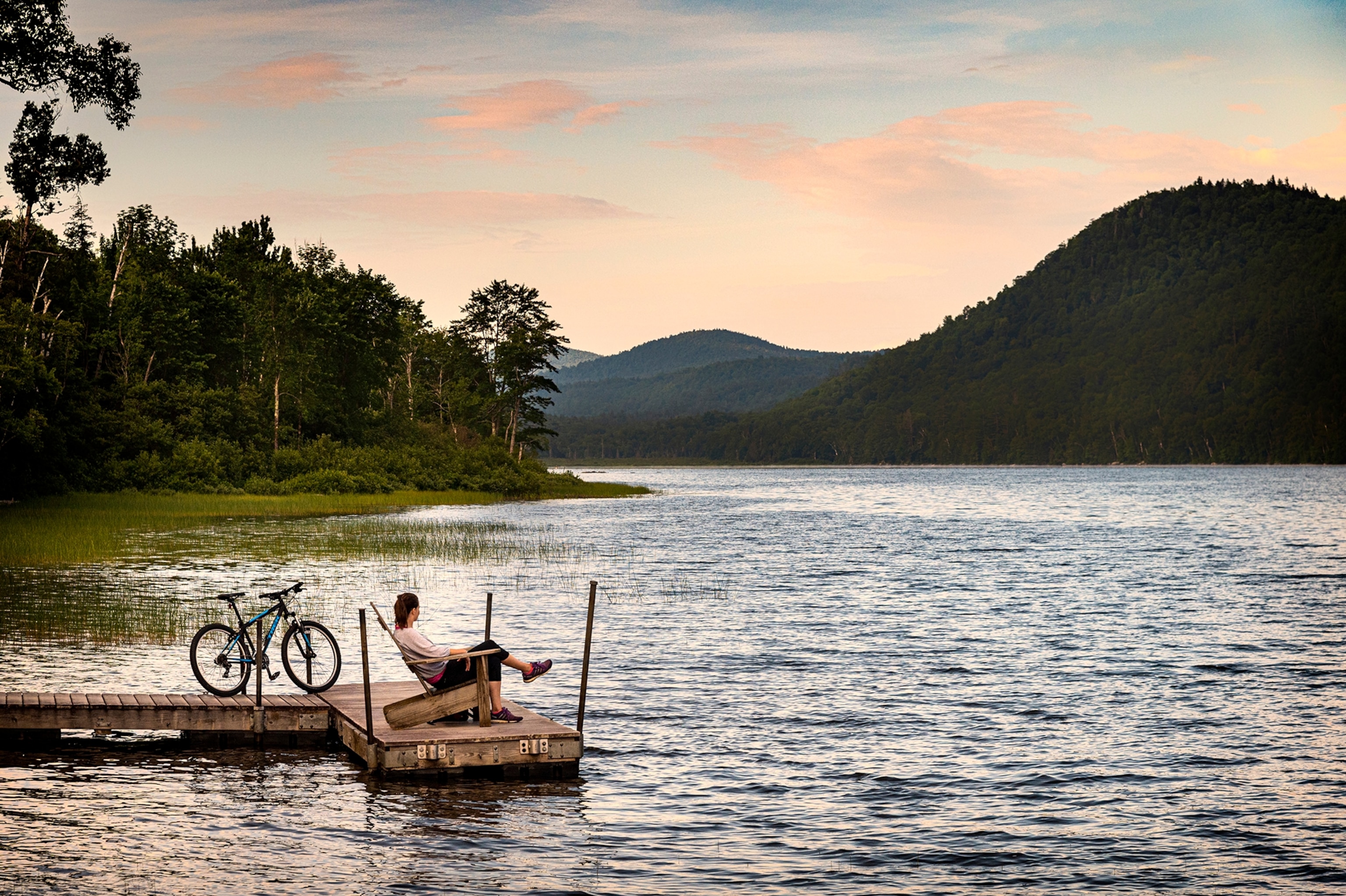
The Adirondacks are the East’s answer to the Rockies—6 million acres of protected wilderness, 46 peaks over 4,000 feet, and zero crowds in August because most people don’t know this region exists outside of winter ski season. The Finger Lakes (11 long, narrow glacial lakes) add wine country charm and swimming holes that beat any beach.
Base yourself in Lake Placid or Saranac Lake (both have hotels, restaurants, and outdoor outfitters) for Adirondack access, or split your time between the mountains and the wine region around Seneca and Cayuga Lakes (Ithaca and Geneva are good home bases). The drive between regions is roughly 2 hours, so you can do both in a 5–7 day trip without feeling scattered.
- Adirondack advantage in August: Crisp mornings (50–60°F), warm afternoons (75–80°F), and the hiking season is at its peak without the mud of spring or the crowds of September.
- Best hikes: Whiteface Mountain (4,867 feet, accessible by car if you skip the hike) or any of the 46-peak “High Peaks” if you’re serious about elevation gain.
- Finger Lakes play: Swim in the lakes (water is cool but swimmable in August), tour a winery, and eat at farm-to-table restaurants that source from local producers.
- Insider tip: The Adirondack Mountain Club website lists all trails with difficulty ratings and parking info—more reliable than generic hiking apps for this region.
Both regions are free to explore; parking at trailheads and attractions varies ($5–$10 per day). Lodging ranges from budget motels to high-end resorts, so pick based on your comfort level.
12. The North Carolina High Country: Pisgah National Forest to Hot Springs
Pisgah National Forest is where serious mountain bikers and hikers go to get humbled—the singletrack here is technical, gnarly, and genuinely fun in a way that feels earned. If you’re not a mountain biker, the hiking and waterfall chasing are equally rewarding, and the landscape is less crowded than the Blue Ridge Parkway corridor.
The route runs through the heart of western North Carolina’s high country, connecting Pisgah National Forest (near Brevard) to the small mountain town of Hot Springs (on the Appalachian Trail). This is not a scenic-drive-only trip—you need to get out and move.
Plan for 3–5 days, with at least one full day dedicated to exploring DuPont State Forest nearby (fast, flowy trails that are more accessible than Pisgah’s gnarliest terrain).
- Best for: Mountain bikers, hikers, and waterfall chasers who want to earn their views.
- Pisgah reality check: Trails are technical and challenging; this isn’t beginner terrain. If you’re new to mountain biking, stick to DuPont State Forest’s easier trails.
- Stay strategy: Base yourself in Brevard (20 minutes from Pisgah’s main trailheads, with good restaurants and lodging) or in the tiny town of Hot Springs itself if you want a quieter, more remote experience.
- August bonus: Water levels in creeks and waterfalls are still decent after summer rain, and the heat is manageable at this elevation (2,000–4,000 feet).
Pisgah National Forest has no entrance fee. Parking at trailheads is free or $5 per day depending on the lot.
This route requires more physical effort than the others, but the payoff is genuine solitude and some of the most challenging terrain east of the Mississippi.
Planning Your Eastern Road Trip in August
August is the sweet spot for Eastern road trips: temperatures are 10–15 degrees cooler than July, school holidays are ending (fewer families on the road), and you avoid the September leaf-peeping crush. However, afternoon thunderstorms are common in the mountains, so plan driving for mornings and hikes for early afternoon when possible.
- Reservation strategy: Book lodging 4–6 weeks in advance, especially in gateway towns like Asheville, Lake Placid, and Ithaca. August fills up faster than you’d expect.
- Gas and supplies: Fill up before entering remote areas (Blue Ridge Parkway, Pisgah National Forest). Convenience stores are sparse, and prices are higher at mountain outposts.
- Navigation: Download offline maps for all four routes—cell coverage is unreliable in the Adirondacks and Appalachian highlands. A physical road atlas is genuinely useful here.
- Weather prep: Pack layers. Mountain temperatures drop 3–5 degrees for every 1,000 feet of elevation gain. A 75°F valley can be 55°F at the summit.
Are Cross-Border Road Trips to Canada Worth it in Late Summer?
Yes—but only if you’re willing to trade convenience for dramatically fewer crowds and cooler temperatures that make August driving actually pleasant. Canadian road trips in late summer deliver what the U.S. routes can’t: uncrowded national parks, stable weather without extreme heat, and the psychological relief of crossing a border that makes the trip feel genuinely different.
The trade-off is longer drive times from most U.S. starting points, tighter booking windows for lodging, and the need to plan around ferry schedules and border crossings. For anyone escaping August heat in the lower 48 states, these three routes are worth the extra logistics.
13. The Golden Circle: A Wilderness Loop Through the Yukon and Alaska
This 300-mile loop from Whitehorse, Yukon, through the Alaskan interior and back is the most remote and rewarding of the three Canadian options—and the most demanding. The route combines the Alaska Highway, the Campbell Highway, and the Taylor Highway into a wilderness drive that passes through genuine frontier landscape: boreal forest, mountain passes, and almost no cell service.
August is the only realistic month to drive this loop; snow closes sections from September onward, and spring breakup makes roads impassable.
The Golden Circle works best as a 4–5 day detour for travelers already committed to reaching Alaska or the Yukon. Base yourself in Whitehorse (the Yukon’s capital and largest town) for gas, supplies, and overnight stays before and after the loop.
The drive itself is rough—gravel sections, minimal services, and wildlife encounters are the norm, not the exception. This is not a scenic byway; it’s a test of commitment.
Bring a full spare tire, extra fuel cans, and supplies because gas stations are 100+ miles apart on stretches of the loop.
- Best for: Adventurers who want genuine wilderness and don’t mind rough roads; photographers chasing boreal forest and mountain light.
- Driving time: Roughly 8–10 hours of actual driving spread over 4–5 days with stops and overnight stays.
- Lodging strategy: Stay in Whitehorse before and after; book cabins or small motels in Dawson City (a historic gold-rush town on the loop) well in advance for August.
- Critical detail: Fuel up in Whitehorse before leaving—prices and availability drop dramatically once you’re on the loop, and running out of gas here is genuinely dangerous.
14. The Icefields Parkway: Navigating Alberta’s Majestic Glacial Peaks
The Icefields Parkway is the opposite of the Golden Circle: a fully paved, heavily touristed, and absolutely stunning 144-mile drive between Lake Louise and Jasper in the Canadian Rockies. August is peak season here, which means crowds at every pullout and full parking lots at major attractions—but the weather is stable, all facilities are open, and the scenery justifies the congestion.
This is the route for travelers who want dramatic mountain views without sacrificing comfort or road quality.
The drive takes 3–4 hours without stops, but plan for a full day to explore properly. The Athabasca Glacier (accessible via a short walk or paid glacier tour) and the turquoise waters of Peyto Lake are the standout stops; both are worth 30–45 minutes each.
The parkway itself is a UNESCO World Heritage Site, and every mile delivers postcard-quality views of glaciers, turquoise lakes, and jagged peaks. Crowds peak between 11 a.m. and 3 p.m., so start early or plan evening stops to avoid the worst congestion.
- Best for: Photographers, families, and anyone prioritizing scenery over solitude; travelers with limited time who want maximum impact.
- Driving time: 3–4 hours of driving; 6–8 hours with proper stops and exploration.
- Lodging strategy: Base yourself in Lake Louise (at the southern end) or Jasper (at the northern end) rather than trying to stay on the parkway itself. Both towns have lodges, hotels, and cabins; book 2–3 months ahead for August.
- Insider detail: The Athabasca Glacier parking lot fills by 10 a.m. in August—arrive by 8:30 a.m. or plan to visit after 5 p.m. when day-trippers leave.
- Cost note: The parkway itself is free to drive, but glacier tours and some activities charge separately; expect roughly $30–60 CAD per person for guided glacier experiences.
15. Prince Edward Island: A Picturesque Journey Through Canada’s Maritimes
Prince Edward Island is the easiest Canadian road trip to access from the U.S. East Coast and the only one that prioritizes charm and culinary stops over wilderness.
The island has the highest concentration of lighthouses in North America—61 total—and three distinct coastal drives that loop around red-sand beaches, fishing villages, and farmland. August weather is warm and stable, beaches are swimmable, and the island’s famous lobster and oyster season is in full swing.
This is the route for travelers who want scenery without roughing it.
Reach Prince Edward Island by driving the 15-kilometer Confederation Bridge from New Brunswick, flying into Charlottetown (the capital), or taking a ferry from Nova Scotia. The island itself is small—only about 140 miles long—so you can drive all three coastal routes in 4–5 days without rushing.
Base yourself in Charlottetown for the most lodging options and restaurant access, or split stays between the island’s small towns to stay closer to specific coastal drives.
| Coastal Drive | Distance | Best For | Highlights |
|---|---|---|---|
| North Cape Coastal Drive | 217 miles (350 km) | Lighthouse lovers and hikers | Red and white sand beaches, windmills, the meeting of the Gulf of St. Lawrence and Northumberland Strait over the longest natural rock reef in North America |
| Central Coastal Drive | 157 miles (253 km) | Literary fans and photographers | Sandstone cliffs, white sand dunes, Cavendish (home to the Anne of Green Gables heritage site), Charlottetown, Confederation Bridge views |
| Points East Coastal Drive | 295 miles (475 km) | Foodies and explorers | 50 beaches, red cliffs, fishing village harbors, colorful starfish signs marking hidden culinary gems, golf courses, farmland |
- Lodging strategy: Charlottetown offers the most hotel and restaurant variety; stay here as a base and day-trip the coastal drives, or book a cottage or waterfront inn in smaller towns like Cavendish or Summerside for a quieter pace.
- Insider detail: The Points East Coastal Drive has colorful starfish signs marking both famous sites and lesser-known local restaurants and attractions—follow them to find the best food and avoid tourist traps.
- Best time to visit: August is peak season for beach weather and lobster/oyster availability, but also peak tourist season; book accommodations 2–3 months ahead.
- Food focus: This is the only route where food is a primary draw—lobster rolls, oyster shacks, and farm-to-table restaurants are concentrated along all three drives, especially the Points East route.
Which Canadian route should you choose? Pick the Golden Circle if you want genuine wilderness and have 5+ days; choose the Icefields Parkway if you want dramatic scenery without logistics headaches; pick Prince Edward Island if you’re on the U.S. East Coast and want charm, food, and easy access.
All three are worth the border crossing in late summer—they deliver what August in the continental U.S. cannot.
How to Successfully Plan Late Summer Road Trips in the USA in August
August road trips require a different strategy than spring or early summer travel—heat, crowds, and fire season closures are real threats that demand advance planning, not improvisation. The difference between a smooth August road trip and a frustrating one comes down to three decisions made before you leave: choosing routes that actually stay cool, carrying navigation tools that work when cell service dies, and understanding wildlife and park reservation rules specific to late summer.
Choosing High-Elevation and Northern Latitudes to Beat the Heat
August heat in the lower 48 is brutal and unpredictable—Death Valley regularly hits 120°F, and even “mild” desert routes can spike to 110°F midday. The smartest move is to drive north or climb elevation, where August temperatures stay genuinely comfortable and fire danger is lower.
- Northern routes win: The North Shore Scenic Drive along Lake Superior, the Cascade Loop through North Cascades National Park, and the Icefields Parkway in Alberta all stay in the 60–75°F range in August. These routes are less crowded than spring or early summer because most families assume August is too hot—it’s not, if you go north.
- High elevation is your second option: Routes through the Rocky Mountains (Glacier National Park to Stanley, Idaho) and the Blue Ridge Parkway stay 15–25°F cooler than surrounding lowlands. Expect temperatures in the 70s–80s even at peak midday.
- Avoid the Southwest entirely in August: Route 66 through Arizona, New Mexico, and Southern California is brutally hot and prone to monsoon storms that can close roads without warning. If Route 66 is your goal, drive it in spring or fall instead.
- Coastal routes offer moderate relief: The Pacific Coast Highway and New England coastlines stay cooler than inland routes, though August is still peak tourist season and parking becomes a real headache.
Essential Navigation Gear: Why You Still Need a Physical Road Atlas
Cell service fails in national parks, mountain passes, and remote stretches—and it fails exactly when you need navigation most. A physical road atlas is not nostalgia; it’s insurance.
- Buy a Rand McNally road atlas before you leave: It works when your phone doesn’t, and it forces you to plan your route instead of reactive turn-by-turn driving. Mark your route in advance so you know exactly which highways to take and where gas stations, water, and lodging are located relative to your position.
- Download offline maps on your phone as backup: Google Maps and Apple Maps both allow offline downloads of specific regions. Download the entire route plus 50 miles on either side.
- Know where cell service actually exists: In grizzly country (Glacier, Yellowstone, the Yukon), cell service is spotty to nonexistent. Plan fuel and water stops around towns, not around your phone’s signal.
- Create a paper backup of critical information: Write down the names, phone numbers, and addresses of your lodging, next gas station, and nearest ranger station on a notecard. This takes five minutes and saves hours of panic.
Safety Precautions for Wildlife Encounters in Grizzly Country
Grizzly bears, moose, and bison are active in August, and late-summer road trips through Glacier National Park, Yellowstone, the Yukon, and Kluane National Park put you in their territory. August is peak feeding season—bears are hungry and unpredictable.
- Kluane National Park in the Yukon has the highest concentration of grizzlies in North America: If you drive the Golden Circle Route through Kluane, assume you will see bears. Keep binoculars in your car, stay in your vehicle, and never approach for a photo. A grizzly can run 35 mph—you cannot outrun one on foot.
- Carry bear spray in Glacier and Yellowstone: Buy it locally (it’s cheaper than shipping) and keep it in your car door pocket, not in the trunk. If you hike, wear it on your hip belt. Make noise on the trail—talk, use a bear bell, or play music. Bears want to avoid you; give them the chance.
- Never feed wildlife or approach for photos: A moose or bison that seems calm is still a 1,000-pound animal that will charge if it feels threatened. The rule is simple: if you can see the animal’s eyes clearly without binoculars, you are too close. Back away slowly.
- Store food and trash properly: If you’re camping or staying in cabins, use bear-proof containers or hang food from bear wires. A single food smell can attract bears to your campsite.
- Drive slowly at dawn and dusk: Wildlife is most active in early morning and evening. Slow driving gives you time to react if an animal crosses the road. Hitting a moose at 60 mph will kill you and the moose.
Managing National Park Crowds and Timed Entry Reservations
August is peak season for most national parks, and popular routes like Acadia, the Blue Ridge Parkway, and Glacier have implemented timed-entry systems and parking caps. Without reservations, you will waste hours searching for parking or be turned away entirely.
- Acadia National Park requires a $6 parking pass during high season: Sunrise hikes up Cadillac Mountain are so popular that the parking lot fills by 5:00 am. Arrive by 3:30 am or skip the sunrise and go at sunset instead. Bring a headlamp if you’re hiking in the dark.
- Book timed-entry reservations 3–6 months in advance: Popular parks like Yellowstone, Zion, and Great Smoky Mountains often sell out by mid-June for August dates. Check the National Park Service website in March and book immediately. If you miss the window, you will not get in.
- Arrive at major overlooks and trailheads before 8:00 am: Parking fills fast in August. The Badlands loop road takes about two hours with stops at overlooks; start at sunrise or sunset when light is best and crowds are thinnest. Sunscreen and a shady hat are non-negotiable—there are few trees for shade on the trails.
- Use the NPS app or call ahead: Road closures, fire restrictions, and water shortages happen in August without warning. Call the park’s main line 24 hours before you arrive to confirm your route is open and your reservation is still valid.
- Plan overnight stops strategically: Base yourself in gateway towns near parks rather than inside them. Towns like Asheville (near Great Smoky Mountains), West Yellowstone (near Yellowstone), and Sedona (near Flagstaff) have more lodging options, better restaurants, and less overnight crowding than park lodges. You’ll drive an extra 30–60 minutes each morning, but you’ll sleep better and eat better.
- Skip the most crowded parks entirely if you’re traveling mid-August: The week before and after mid-August sees the worst crowds. If your dates are flexible, shift your trip to late July or early September instead. The weather is nearly identical, but crowds drop by 40–50 percent.
Frequently Asked Questions
Is August a good month for a cross-country road trip?
August is viable but comes with trade-offs. You’ll have long daylight hours and school breaks make family travel easier, but expect peak summer crowds on major routes like Route 66 and the Pacific Coast Highway, plus higher gas prices and rental car rates.
August works best if you’re targeting high-elevation routes (Northern Cascades, Icefields Parkway, High Rockies) where cooler temperatures actually make driving and hiking comfortable. Low-elevation desert routes (Route 66, volcanic byways in Oregon) become brutally hot—plan early morning drives and midday breaks near water or air conditioning.
Which US road trip has the best weather in late summer?
The North Shore Scenic Drive along Lake Superior and routes through the Upper Midwest (Great Lakes Circle Tour, Minnesota’s North Shore) deliver the most reliably cool weather in August, typically in the 70s°F with lake breezes. High-elevation western routes—the Icefields Parkway in Alberta, the Northern Cascades loop, and the High Rockies (Glacier to Stanley)—also stay pleasantly cool.
Avoid low desert sections of Route 66 and the volcanic byways in central Oregon unless you’re prepared for 90°F+ heat and plan all hiking for dawn. The Blue Ridge Parkway and New England coast offer moderate temperatures but expect afternoon thunderstorms, especially in the Appalachian sections.
How do I avoid heavy traffic during August travel?
Travel mid-week (Tuesday through Thursday) instead of weekends—Friday through Sunday see the heaviest congestion on all major routes. Start drives before 7 a.m. to beat day-trippers and families heading to popular overlooks and trailheads.
Avoid peak tourist hours at major attractions: sunrise at Crater Lake, midday at Badlands National Park, and late afternoon at Blue Ridge Parkway overlooks. Secondary routes consistently outperform famous highways—take the North Carolina High Country route through Pisgah National Forest instead of the main Blue Ridge corridor, or explore Upstate New York’s Finger Lakes and Adirondacks instead of the crowded New England coast.
Booking lodging in smaller gateway towns (not the most famous park entrances) also means shorter morning drives to trailheads before crowds arrive.
What are the best family-friendly road trips for late summer?
The Great Lakes Circle Tour (Indiana Dunes to Apostle Islands) and South Dakota’s Badlands-to-Black Hills loop are ideal for families—short driving days, multiple activity options, and established infrastructure. Badlands National Park specifically rewards a two-day stop: the loop road takes roughly two hours with overlook stops, and sunrise or sunset visits showcase the layered sandstone colors best.
Bring sunscreen and wide-brimmed hats; the park has minimal shade on trails. Route 66 works for families seeking Americana nostalgia and quirky roadside stops, though the desert sections require air-conditioned breaks.
Prince Edward Island’s picturesque maritime loop suits families wanting gentler scenery and beach time without extreme heat. Avoid high-elevation technical routes (Icefields Parkway, Northern Cascades) with young children unless they’re experienced hikers—these routes demand early starts and have limited services.
Are rental cars more expensive for August road trips?
Yes—expect 20–40% higher daily rates in August compared to shoulder seasons (May, June, September). Book at least 4–6 weeks in advance to secure better pricing and vehicle availability.
Mid-size SUVs and sedans typically cost less than premium or specialty vehicles. One-way rentals (picking up in one city, dropping in another) cost more than round-trip, so factor that into route planning.
Gas prices also spike in summer, so fuel efficiency matters—hybrid or smaller vehicles reduce per-mile costs. Consider flying into a secondary airport or picking up your car outside peak tourist areas (not at major park gateways) to avoid premium location fees.
If you’re flexible on dates, traveling the first or last week of August instead of mid-month can save 15–25% on rental rates.
Pick Your Route and Commit
The honest move is to stop overthinking and choose based on how many days you have and what actually excites you. If you have a long weekend, the Volcanic Legacy Byway or North Shore Superior drive delivers impact without rushing; if you have a full week, the Pacific Coast Highway or Blue Ridge Parkway reward slow exploration; if you’re willing to commit 5+ days to wilderness, Glacier to Stanley or the Golden Circle will change how you think about driving.
August road trips work because you’re traveling during the exact window when high-elevation roads are snow-free, wildflowers are still blooming, and wildlife is most active—conditions that don’t exist in spring or fall. The crowds are real, but they’re manageable if you start before 7 a.m., skip the most famous parks if you’re traveling mid-August, and base yourself in smaller gateway towns instead of park lodges.
Book your lodging this week, download offline maps, and commit to a start date within the next month—August fills fast, and the difference between traveling the first week and mid-month is the difference between finding a parking spot and driving an extra 90 minutes to the next town.
Leave a Reply